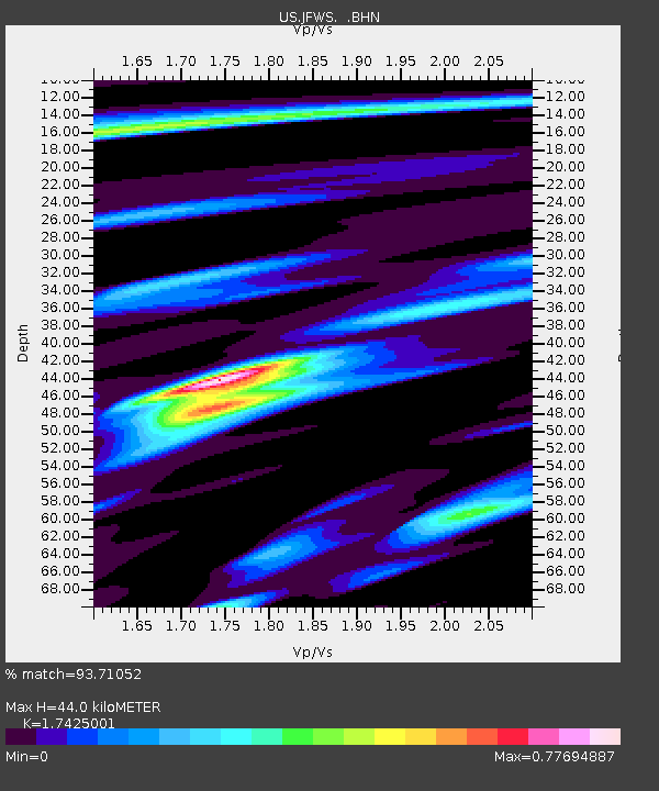
JFWS Jewell Farm, Wisconsin, USA - Earthquake Result Viewer

Earthquake location: Rat Islands, Aleutian Islands
Earthquake latitude/longitude: 51.1/178.6
Earthquake time(UTC): 2003/11/17 (321) 06:43:06 GMT
Earthquake Depth: 33 km
Earthquake Magnitude: 6.2 MB, 7.2 MS, 7.8 MW, 7.7 MW
Earthquake Catalog/Contributor: WHDF/NEIC
Network: US United States National Seismic Network
Station: JFWS Jewell Farm, Wisconsin, USA
Lat/Lon: 42.91 N/90.25 W
Elevation: 335 m
Distance: 58.8 deg
Az: 59.173 deg
Baz: 312.585 deg
Ray Param: 0.062551804
Estimated Moho Depth: 44.0 km
Estimated Crust Vp/Vs: 1.74
Assumed Crust Vp: 6.53 km/s
Estimated Crust Vs: 3.748 km/s
Estimated Crust Poisson's Ratio: 0.25
Radial Match: 93.71052 %
Radial Bump: 400
Transverse Match: 80.92765 %
Transverse Bump: 400
SOD ConfigId: 110177
Insert Time: 2010-03-05 01:54:45.997 +0000
GWidth: 2.5
Max Bumps: 400
Tol: 0.001

Signal To Noise

ChannelStoNSTALTA
US:JFWS: :BHN:20031117T06:52:31.104016Z1.40436945.9726386E-74.2528973E-7
US:JFWS: :BHE:20031117T06:52:31.104016Z0.880174044.5295286E-75.146174E-7
US:JFWS: :BHZ:20031117T06:52:31.104016Z2.56310491.8887342E-67.3689307E-7
Arrivals
Ps5.3 SECOND
PpPs18 SECOND
PsPs/PpSs23 SECOND