You are here: Home > Network List > 7A - Mid-Atlantic Geophysical Integrative Collaboration Stations List
> Station BDEG Charles Lake, Virginia USA > Earthquake Result Viewer
BDEG Charles Lake, Virginia USA - Earthquake Result Viewer
| Earthquake location: |
Near Coast Of Ecuador |
| Earthquake latitude/longitude: |
0.6/-80.3 |
| Earthquake time(UTC): |
2016/04/20 (111) 08:33:48 GMT |
| Earthquake Depth: |
16 km |
| Earthquake Magnitude: |
6.1 MO |
| Earthquake Catalog/Contributor: |
NEIC PDE/NEIC ALERT |
|
| Network: |
7A Mid-Atlantic Geophysical Integrative Collaboration |
| Station: |
BDEG Charles Lake, Virginia USA |
| Lat/Lon: |
37.33 N/77.21 W |
| Elevation: |
-21.0 m |
|
| Distance: |
36.7 deg |
| Az: |
4.077 deg |
| Baz: |
185.117 deg |
| Ray Param: |
0.07654948 |
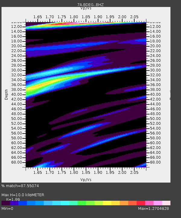
| Estimated Moho Depth: |
10.0 km |
| Estimated Crust Vp/Vs: |
1.86 |
| Assumed Crust Vp: |
6.565 km/s |
| Estimated Crust Vs: |
3.529 km/s |
| Estimated Crust Poisson's Ratio: |
0.30 |
|
| Radial Match: |
87.55074 % |
| Radial Bump: |
400 |
| Transverse Match: |
65.2203 % |
| Transverse Bump: |
400 |
| SOD ConfigId: |
7422571 |
| Insert Time: |
2019-04-22 09:40:22.197 +0000 |
| GWidth: |
2.5 |
| Max Bumps: |
400 |
| Tol: |
0.001 |
|

Signal To Noise
| Channel | StoN | STA | LTA |
| 7A:BDEG: :BHZ:20160420T08:40:22.234985Z | 4.643508 | 5.829502E-7 | 1.255409E-7 |
| 7A:BDEG: :BHN:20160420T08:40:22.234985Z | 2.9135244 | 3.3390359E-7 | 1.14604696E-7 |
| 7A:BDEG: :BHE:20160420T08:40:22.234985Z | 1.4351507 | 1.8915239E-7 | 1.3179965E-7 |
| Arrivals |
| Ps | 1.4 SECOND |
| PpPs | 4.0 SECOND |
| PsPs/PpSs | 5.5 SECOND |


