You are here: Home > Network List > 7A - Mid-Atlantic Geophysical Integrative Collaboration Stations List
> Station AZZI Ashley, Ohio USA > Earthquake Result Viewer
AZZI Ashley, Ohio USA - Earthquake Result Viewer
| Earthquake location: |
Near Coast Of Ecuador |
| Earthquake latitude/longitude: |
0.6/-80.3 |
| Earthquake time(UTC): |
2016/04/20 (111) 08:33:48 GMT |
| Earthquake Depth: |
16 km |
| Earthquake Magnitude: |
6.1 MO |
| Earthquake Catalog/Contributor: |
NEIC PDE/NEIC ALERT |
|
| Network: |
7A Mid-Atlantic Geophysical Integrative Collaboration |
| Station: |
AZZI Ashley, Ohio USA |
| Lat/Lon: |
40.37 N/82.92 W |
| Elevation: |
294 m |
|
| Distance: |
39.6 deg |
| Az: |
356.816 deg |
| Baz: |
175.831 deg |
| Ray Param: |
0.07484823 |
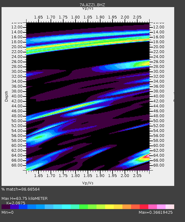
| Estimated Moho Depth: |
63.75 km |
| Estimated Crust Vp/Vs: |
2.10 |
| Assumed Crust Vp: |
6.498 km/s |
| Estimated Crust Vs: |
3.098 km/s |
| Estimated Crust Poisson's Ratio: |
0.35 |
|
| Radial Match: |
86.66564 % |
| Radial Bump: |
283 |
| Transverse Match: |
69.3426 % |
| Transverse Bump: |
400 |
| SOD ConfigId: |
7422571 |
| Insert Time: |
2019-04-22 09:40:22.322 +0000 |
| GWidth: |
2.5 |
| Max Bumps: |
400 |
| Tol: |
0.001 |
|

Signal To Noise
| Channel | StoN | STA | LTA |
| 7A:AZZI: :BHZ:20160420T08:40:47.505005Z | 4.6571 | 5.189438E-7 | 1.11430666E-7 |
| 7A:AZZI: :BH1:20160420T08:40:47.505005Z | 2.3105152 | 3.3483784E-7 | 1.4491913E-7 |
| 7A:AZZI: :BH2:20160420T08:40:47.505005Z | 0.52335733 | 5.190722E-8 | 9.918122E-8 |
| Arrivals |
| Ps | 11 SECOND |
| PpPs | 29 SECOND |
| PsPs/PpSs | 40 SECOND |


