You are here: Home > Network List > 7A - Mid-Atlantic Geophysical Integrative Collaboration Stations List
> Station KENT Kenton, Ohio USA > Earthquake Result Viewer
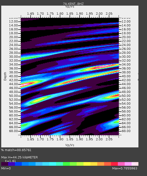
KENT Kenton, Ohio USA - Earthquake Result Viewer
| Earthquake location: |
Near Coast Of Ecuador |
| Earthquake latitude/longitude: |
0.6/-80.3 |
| Earthquake time(UTC): |
2016/04/20 (111) 08:33:48 GMT |
| Earthquake Depth: |
16 km |
| Earthquake Magnitude: |
6.1 MO |
| Earthquake Catalog/Contributor: |
NEIC PDE/NEIC ALERT |
|
| Network: |
7A Mid-Atlantic Geophysical Integrative Collaboration |
| Station: |
KENT Kenton, Ohio USA |
| Lat/Lon: |
40.63 N/83.64 W |
| Elevation: |
296 m |
|
| Distance: |
40.0 deg |
| Az: |
355.999 deg |
| Baz: |
174.74 deg |
| Ray Param: |
0.074664176 |
| Estimated Moho Depth: |
44.25 km |
| Estimated Crust Vp/Vs: |
1.61 |
| Assumed Crust Vp: |
6.498 km/s |
| Estimated Crust Vs: |
4.036 km/s |
| Estimated Crust Poisson's Ratio: |
0.19 |
|
| Radial Match: |
88.65761 % |
| Radial Bump: |
325 |
| Transverse Match: |
57.200638 % |
| Transverse Bump: |
400 |
| SOD ConfigId: |
7422571 |
| Insert Time: |
2019-04-22 09:40:29.720 +0000 |
| GWidth: |
2.5 |
| Max Bumps: |
400 |
| Tol: |
0.001 |
|

Signal To Noise
| Channel | StoN | STA | LTA |
| 7A:KENT: :BHZ:20160420T08:40:50.029999Z | 3.1615055 | 4.4454939E-7 | 1.406132E-7 |
| 7A:KENT: :BHN:20160420T08:40:50.029999Z | 2.3576686 | 2.3338345E-7 | 9.8989084E-8 |
| 7A:KENT: :BHE:20160420T08:40:50.029999Z | 0.61189353 | 7.509982E-8 | 1.2273348E-7 |
| Arrivals |
| Ps | 4.5 SECOND |
| PpPs | 16 SECOND |
| PsPs/PpSs | 21 SECOND |


