You are here: Home > Network List > 7A - Mid-Atlantic Geophysical Integrative Collaboration Stations List
> Station NAZF Center Point, West Virginia USA > Earthquake Result Viewer
NAZF Center Point, West Virginia USA - Earthquake Result Viewer
| Earthquake location: |
Near Coast Of Ecuador |
| Earthquake latitude/longitude: |
0.6/-80.3 |
| Earthquake time(UTC): |
2016/04/20 (111) 08:33:48 GMT |
| Earthquake Depth: |
16 km |
| Earthquake Magnitude: |
6.1 MO |
| Earthquake Catalog/Contributor: |
NEIC PDE/NEIC ALERT |
|
| Network: |
7A Mid-Atlantic Geophysical Integrative Collaboration |
| Station: |
NAZF Center Point, West Virginia USA |
| Lat/Lon: |
39.38 N/80.64 W |
| Elevation: |
0.0 m |
|
| Distance: |
38.6 deg |
| Az: |
359.528 deg |
| Baz: |
179.392 deg |
| Ray Param: |
0.07545864 |
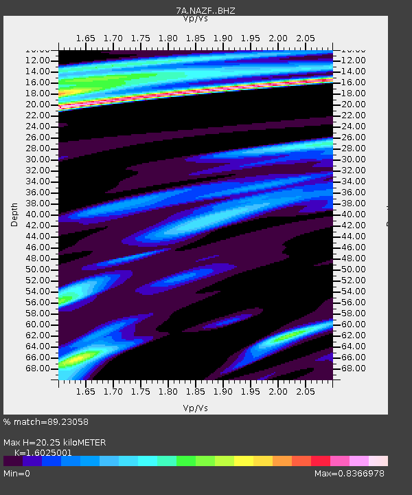
| Estimated Moho Depth: |
20.25 km |
| Estimated Crust Vp/Vs: |
1.60 |
| Assumed Crust Vp: |
6.207 km/s |
| Estimated Crust Vs: |
3.873 km/s |
| Estimated Crust Poisson's Ratio: |
0.18 |
|
| Radial Match: |
89.23058 % |
| Radial Bump: |
291 |
| Transverse Match: |
65.08979 % |
| Transverse Bump: |
400 |
| SOD ConfigId: |
7422571 |
| Insert Time: |
2019-04-22 09:40:34.590 +0000 |
| GWidth: |
2.5 |
| Max Bumps: |
400 |
| Tol: |
0.001 |
|

Signal To Noise
| Channel | StoN | STA | LTA |
| 7A:NAZF: :BHZ:20160420T08:40:38.654999Z | 2.6642408 | 4.728151E-7 | 1.774671E-7 |
| 7A:NAZF: :BHN:20160420T08:40:38.654999Z | 1.2331831 | 2.0159459E-7 | 1.6347498E-7 |
| 7A:NAZF: :BHE:20160420T08:40:38.654999Z | 0.9836979 | 1.06115124E-7 | 1.07873696E-7 |
| Arrivals |
| Ps | 2.1 SECOND |
| PpPs | 7.9 SECOND |
| PsPs/PpSs | 10.0 SECOND |


