You are here: Home > Network List > N4 - Central and EAstern US Network Stations List
> Station 255A Hazlehurst, GA, USA > Earthquake Result Viewer
255A Hazlehurst, GA, USA - Earthquake Result Viewer
| Earthquake location: |
Near Coast Of Ecuador |
| Earthquake latitude/longitude: |
0.6/-80.3 |
| Earthquake time(UTC): |
2016/04/20 (111) 08:33:48 GMT |
| Earthquake Depth: |
16 km |
| Earthquake Magnitude: |
6.1 MO |
| Earthquake Catalog/Contributor: |
NEIC PDE/NEIC ALERT |
|
| Network: |
N4 Central and EAstern US Network |
| Station: |
255A Hazlehurst, GA, USA |
| Lat/Lon: |
31.93 N/82.48 W |
| Elevation: |
45 m |
|
| Distance: |
31.2 deg |
| Az: |
356.364 deg |
| Baz: |
175.723 deg |
| Ray Param: |
0.079118945 |
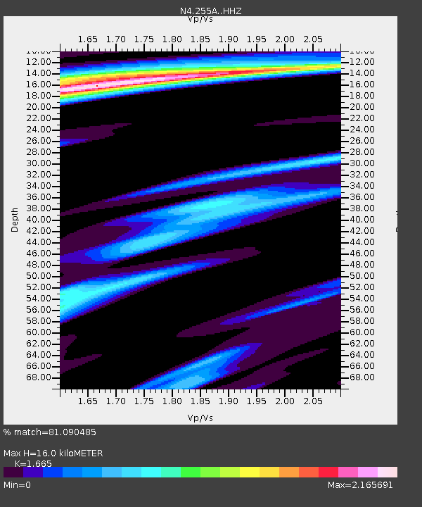
| Estimated Moho Depth: |
16.0 km |
| Estimated Crust Vp/Vs: |
1.66 |
| Assumed Crust Vp: |
6.565 km/s |
| Estimated Crust Vs: |
3.943 km/s |
| Estimated Crust Poisson's Ratio: |
0.22 |
|
| Radial Match: |
81.090485 % |
| Radial Bump: |
363 |
| Transverse Match: |
63.582092 % |
| Transverse Bump: |
400 |
| SOD ConfigId: |
7422571 |
| Insert Time: |
2019-04-22 09:45:54.187 +0000 |
| GWidth: |
2.5 |
| Max Bumps: |
400 |
| Tol: |
0.001 |
|

Signal To Noise
| Channel | StoN | STA | LTA |
| N4:255A: :HHZ:20160420T08:39:35.269989Z | 2.3553832 | 4.6679122E-7 | 1.981806E-7 |
| N4:255A: :HHN:20160420T08:39:35.269989Z | 1.5754057 | 6.4361643E-7 | 4.085401E-7 |
| N4:255A: :HHE:20160420T08:39:35.269989Z | 0.89035034 | 2.7544635E-7 | 3.093685E-7 |
| Arrivals |
| Ps | 1.8 SECOND |
| PpPs | 5.9 SECOND |
| PsPs/PpSs | 7.7 SECOND |


