You are here: Home > Network List > N4 - Central and EAstern US Network Stations List
> Station T47A Sharon Grove, KY, USA > Earthquake Result Viewer
T47A Sharon Grove, KY, USA - Earthquake Result Viewer
| Earthquake location: |
Near Coast Of Ecuador |
| Earthquake latitude/longitude: |
0.6/-80.3 |
| Earthquake time(UTC): |
2016/04/20 (111) 08:33:48 GMT |
| Earthquake Depth: |
16 km |
| Earthquake Magnitude: |
6.1 MO |
| Earthquake Catalog/Contributor: |
NEIC PDE/NEIC ALERT |
|
| Network: |
N4 Central and EAstern US Network |
| Station: |
T47A Sharon Grove, KY, USA |
| Lat/Lon: |
36.99 N/87.11 W |
| Elevation: |
217 m |
|
| Distance: |
36.8 deg |
| Az: |
350.823 deg |
| Baz: |
168.511 deg |
| Ray Param: |
0.07649577 |
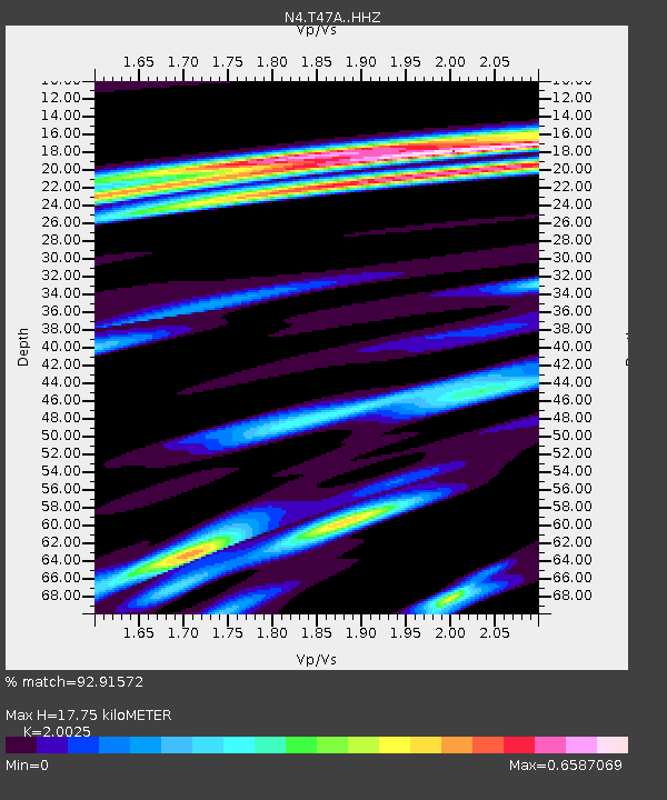
| Estimated Moho Depth: |
17.75 km |
| Estimated Crust Vp/Vs: |
2.00 |
| Assumed Crust Vp: |
6.444 km/s |
| Estimated Crust Vs: |
3.218 km/s |
| Estimated Crust Poisson's Ratio: |
0.33 |
|
| Radial Match: |
92.91572 % |
| Radial Bump: |
239 |
| Transverse Match: |
67.77678 % |
| Transverse Bump: |
400 |
| SOD ConfigId: |
7422571 |
| Insert Time: |
2019-04-22 09:47:08.273 +0000 |
| GWidth: |
2.5 |
| Max Bumps: |
400 |
| Tol: |
0.001 |
|

Signal To Noise
| Channel | StoN | STA | LTA |
| N4:T47A: :HHZ:20160420T08:40:23.179993Z | 3.710052 | 4.099192E-7 | 1.10488806E-7 |
| N4:T47A: :HHN:20160420T08:40:23.179993Z | 3.1782598 | 2.551566E-7 | 8.028186E-8 |
| N4:T47A: :HHE:20160420T08:40:23.179993Z | 1.2943851 | 1.2217755E-7 | 9.439042E-8 |
| Arrivals |
| Ps | 2.9 SECOND |
| PpPs | 7.7 SECOND |
| PsPs/PpSs | 11 SECOND |


