You are here: Home > Network List > NM - Cooperative New Madrid Seismic Network Stations List
> Station PVMO UM Delta Research Portageville, MO > Earthquake Result Viewer
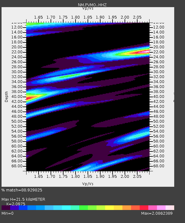
PVMO UM Delta Research Portageville, MO - Earthquake Result Viewer
| Earthquake location: |
Near Coast Of Ecuador |
| Earthquake latitude/longitude: |
0.6/-80.3 |
| Earthquake time(UTC): |
2016/04/20 (111) 08:33:48 GMT |
| Earthquake Depth: |
16 km |
| Earthquake Magnitude: |
6.1 MO |
| Earthquake Catalog/Contributor: |
NEIC PDE/NEIC ALERT |
|
| Network: |
NM Cooperative New Madrid Seismic Network |
| Station: |
PVMO UM Delta Research Portageville, MO |
| Lat/Lon: |
36.41 N/89.70 W |
| Elevation: |
98 m |
|
| Distance: |
36.7 deg |
| Az: |
347.208 deg |
| Baz: |
164.069 deg |
| Ray Param: |
0.076529935 |
| Estimated Moho Depth: |
21.5 km |
| Estimated Crust Vp/Vs: |
2.10 |
| Assumed Crust Vp: |
6.444 km/s |
| Estimated Crust Vs: |
3.072 km/s |
| Estimated Crust Poisson's Ratio: |
0.35 |
|
| Radial Match: |
88.929825 % |
| Radial Bump: |
373 |
| Transverse Match: |
60.753315 % |
| Transverse Bump: |
400 |
| SOD ConfigId: |
7422571 |
| Insert Time: |
2019-04-22 09:47:40.431 +0000 |
| GWidth: |
2.5 |
| Max Bumps: |
400 |
| Tol: |
0.001 |
|

Signal To Noise
| Channel | StoN | STA | LTA |
| NM:PVMO: :HHZ:20160420T08:40:22.670013Z | 2.0918853 | 1.5890924E-6 | 7.5964607E-7 |
| NM:PVMO: :HHN:20160420T08:40:22.670013Z | 1.3540803 | 1.1893884E-6 | 8.7837356E-7 |
| NM:PVMO: :HHE:20160420T08:40:22.670013Z | 1.2934033 | 1.0014363E-6 | 7.742646E-7 |
| Arrivals |
| Ps | 3.9 SECOND |
| PpPs | 9.7 SECOND |
| PsPs/PpSs | 14 SECOND |


