You are here: Home > Network List > SC - New Mexico Tech Seismic Network Stations List
> Station Y22A Socorro, NM, USA > Earthquake Result Viewer
Y22A Socorro, NM, USA - Earthquake Result Viewer
| Earthquake location: |
Near Coast Of Ecuador |
| Earthquake latitude/longitude: |
0.6/-80.3 |
| Earthquake time(UTC): |
2016/04/20 (111) 08:33:48 GMT |
| Earthquake Depth: |
16 km |
| Earthquake Magnitude: |
6.1 MO |
| Earthquake Catalog/Contributor: |
NEIC PDE/NEIC ALERT |
|
| Network: |
SC New Mexico Tech Seismic Network |
| Station: |
Y22A Socorro, NM, USA |
| Lat/Lon: |
33.94 N/106.97 W |
| Elevation: |
1674 m |
|
| Distance: |
41.5 deg |
| Az: |
325.708 deg |
| Baz: |
137.341 deg |
| Ray Param: |
0.073712654 |
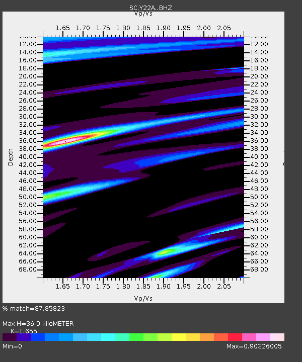
| Estimated Moho Depth: |
36.0 km |
| Estimated Crust Vp/Vs: |
1.65 |
| Assumed Crust Vp: |
6.502 km/s |
| Estimated Crust Vs: |
3.928 km/s |
| Estimated Crust Poisson's Ratio: |
0.21 |
|
| Radial Match: |
87.85823 % |
| Radial Bump: |
400 |
| Transverse Match: |
77.94153 % |
| Transverse Bump: |
400 |
| SOD ConfigId: |
7422571 |
| Insert Time: |
2019-04-22 09:49:35.015 +0000 |
| GWidth: |
2.5 |
| Max Bumps: |
400 |
| Tol: |
0.001 |
|

Signal To Noise
| Channel | StoN | STA | LTA |
| SC:Y22A: :BHZ:20160420T08:41:03.373993Z | 6.2175617 | 1.0209543E-6 | 1.6420492E-7 |
| SC:Y22A: :BHN:20160420T08:41:03.373993Z | 1.532813 | 3.983034E-7 | 2.5985125E-7 |
| SC:Y22A: :BHE:20160420T08:41:03.373993Z | 2.6791642 | 4.6080882E-7 | 1.7199723E-7 |
| Arrivals |
| Ps | 3.9 SECOND |
| PpPs | 14 SECOND |
| PsPs/PpSs | 18 SECOND |


