You are here: Home > Network List > SN - Southern Great Basin Network Stations List
> Station HEL Hell's Gate, California w84 > Earthquake Result Viewer
HEL Hell's Gate, California w84 - Earthquake Result Viewer
| Earthquake location: |
Near Coast Of Ecuador |
| Earthquake latitude/longitude: |
0.6/-80.3 |
| Earthquake time(UTC): |
2016/04/20 (111) 08:33:48 GMT |
| Earthquake Depth: |
16 km |
| Earthquake Magnitude: |
6.1 MO |
| Earthquake Catalog/Contributor: |
NEIC PDE/NEIC ALERT |
|
| Network: |
SN Southern Great Basin Network |
| Station: |
HEL Hell's Gate, California w84 |
| Lat/Lon: |
36.72 N/116.98 W |
| Elevation: |
747 m |
|
| Distance: |
49.4 deg |
| Az: |
320.784 deg |
| Baz: |
128.104 deg |
| Ray Param: |
0.06868574 |
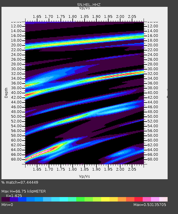
| Estimated Moho Depth: |
66.75 km |
| Estimated Crust Vp/Vs: |
1.62 |
| Assumed Crust Vp: |
6.279 km/s |
| Estimated Crust Vs: |
3.864 km/s |
| Estimated Crust Poisson's Ratio: |
0.20 |
|
| Radial Match: |
87.44449 % |
| Radial Bump: |
228 |
| Transverse Match: |
68.585884 % |
| Transverse Bump: |
340 |
| SOD ConfigId: |
7422571 |
| Insert Time: |
2019-04-22 09:49:38.985 +0000 |
| GWidth: |
2.5 |
| Max Bumps: |
400 |
| Tol: |
0.001 |
|

Signal To Noise
| Channel | StoN | STA | LTA |
| SN:HEL: :HHZ:20160420T08:42:05.858002Z | 5.4863963 | 8.1678684E-7 | 1.4887493E-7 |
| SN:HEL: :HHN:20160420T08:42:05.858002Z | 1.3382794 | 2.5648887E-7 | 1.916557E-7 |
| SN:HEL: :HHE:20160420T08:42:05.858002Z | 2.956864 | 3.9917603E-7 | 1.349998E-7 |
| Arrivals |
| Ps | 7.1 SECOND |
| PpPs | 26 SECOND |
| PsPs/PpSs | 33 SECOND |


