You are here: Home > Network List > TA - USArray Transportable Network (new EarthScope stations) Stations List
> Station 435B Jarrell, TX, USA > Earthquake Result Viewer
435B Jarrell, TX, USA - Earthquake Result Viewer

| Earthquake location: |
Near Coast Of Ecuador |
| Earthquake latitude/longitude: |
0.6/-80.3 |
| Earthquake time(UTC): |
2016/04/20 (111) 08:33:48 GMT |
| Earthquake Depth: |
16 km |
| Earthquake Magnitude: |
6.1 MO |
| Earthquake Catalog/Contributor: |
NEIC PDE/NEIC ALERT |
|
| Network: |
TA USArray Transportable Network (new EarthScope stations) |
| Station: |
435B Jarrell, TX, USA |
| Lat/Lon: |
30.78 N/97.58 W |
| Elevation: |
248 m |
|
| Distance: |
34.2 deg |
| Az: |
332.89 deg |
| Baz: |
148.03 deg |
| Ray Param: |
0.077835135 |
| Estimated Moho Depth: |
17.75 km |
| Estimated Crust Vp/Vs: |
1.60 |
| Assumed Crust Vp: |
6.347 km/s |
| Estimated Crust Vs: |
3.967 km/s |
| Estimated Crust Poisson's Ratio: |
0.18 |
|
| Radial Match: |
93.67986 % |
| Radial Bump: |
258 |
| Transverse Match: |
78.96214 % |
| Transverse Bump: |
400 |
| SOD ConfigId: |
7422571 |
| Insert Time: |
2019-04-22 09:49:45.384 +0000 |
| GWidth: |
2.5 |
| Max Bumps: |
400 |
| Tol: |
0.001 |
|
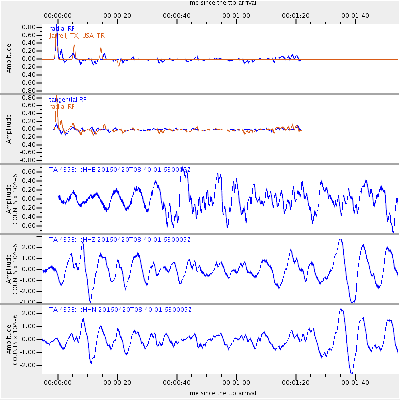
Signal To Noise
| Channel | StoN | STA | LTA |
| TA:435B: :HHZ:20160420T08:40:01.630005Z | 4.3181257 | 9.200252E-7 | 2.1306123E-7 |
| TA:435B: :HHN:20160420T08:40:01.630005Z | 4.2306113 | 3.7155056E-7 | 8.7824326E-8 |
| TA:435B: :HHE:20160420T08:40:01.630005Z | 2.090024 | 2.440998E-7 | 1.16792826E-7 |
| Arrivals |
| Ps | 1.8 SECOND |
| PpPs | 6.7 SECOND |
| PsPs/PpSs | 8.5 SECOND |


