You are here: Home > Network List > TA - USArray Transportable Network (new EarthScope stations) Stations List
> Station J26L Joseph Creek, AK, USA > Earthquake Result Viewer
J26L Joseph Creek, AK, USA - Earthquake Result Viewer
| Earthquake location: |
Near Coast Of Ecuador |
| Earthquake latitude/longitude: |
0.6/-80.3 |
| Earthquake time(UTC): |
2016/04/20 (111) 08:33:48 GMT |
| Earthquake Depth: |
16 km |
| Earthquake Magnitude: |
6.1 MO |
| Earthquake Catalog/Contributor: |
NEIC PDE/NEIC ALERT |
|
| Network: |
TA USArray Transportable Network (new EarthScope stations) |
| Station: |
J26L Joseph Creek, AK, USA |
| Lat/Lon: |
64.50 N/143.56 W |
| Elevation: |
1144 m |
|
| Distance: |
78.2 deg |
| Az: |
336.734 deg |
| Baz: |
114.144 deg |
| Ray Param: |
0.049769953 |
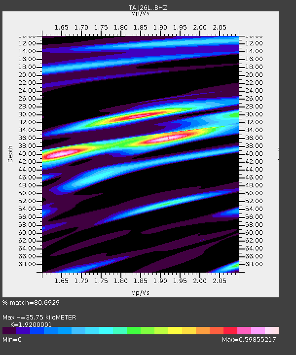
| Estimated Moho Depth: |
35.75 km |
| Estimated Crust Vp/Vs: |
1.92 |
| Assumed Crust Vp: |
6.566 km/s |
| Estimated Crust Vs: |
3.42 km/s |
| Estimated Crust Poisson's Ratio: |
0.31 |
|
| Radial Match: |
80.6929 % |
| Radial Bump: |
379 |
| Transverse Match: |
74.991325 % |
| Transverse Bump: |
348 |
| SOD ConfigId: |
7422571 |
| Insert Time: |
2019-04-22 09:50:09.604 +0000 |
| GWidth: |
2.5 |
| Max Bumps: |
400 |
| Tol: |
0.001 |
|
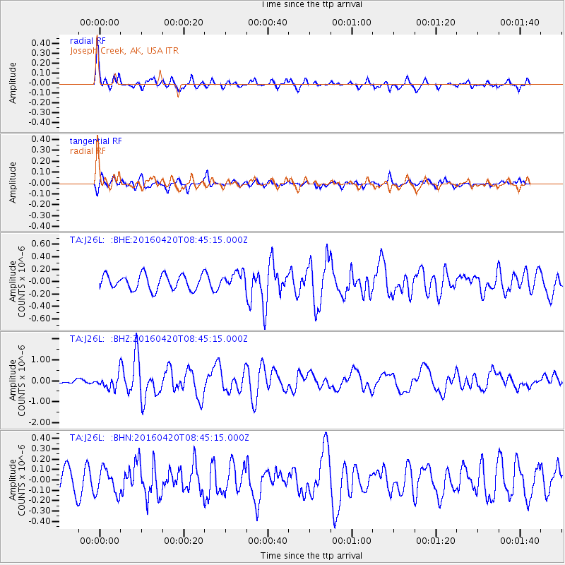
Signal To Noise
| Channel | StoN | STA | LTA |
| TA:J26L: :BHZ:20160420T08:45:15.000Z | 3.3796468 | 3.1881137E-7 | 9.433275E-8 |
| TA:J26L: :BHN:20160420T08:45:15.000Z | 1.3524599 | 1.1970846E-7 | 8.851166E-8 |
| TA:J26L: :BHE:20160420T08:45:15.000Z | 1.2059093 | 1.4814506E-7 | 1.2284926E-7 |
| Arrivals |
| Ps | 5.2 SECOND |
| PpPs | 15 SECOND |
| PsPs/PpSs | 21 SECOND |


