You are here: Home > Network List > TA - USArray Transportable Network (new EarthScope stations) Stations List
> Station L26K Log Cabin Wilderness Lodge, Tok, AK, USA > Earthquake Result Viewer
L26K Log Cabin Wilderness Lodge, Tok, AK, USA - Earthquake Result Viewer
| Earthquake location: |
Near Coast Of Ecuador |
| Earthquake latitude/longitude: |
0.6/-80.3 |
| Earthquake time(UTC): |
2016/04/20 (111) 08:33:48 GMT |
| Earthquake Depth: |
16 km |
| Earthquake Magnitude: |
6.1 MO |
| Earthquake Catalog/Contributor: |
NEIC PDE/NEIC ALERT |
|
| Network: |
TA USArray Transportable Network (new EarthScope stations) |
| Station: |
L26K Log Cabin Wilderness Lodge, Tok, AK, USA |
| Lat/Lon: |
63.03 N/143.35 W |
| Elevation: |
650 m |
|
| Distance: |
77.5 deg |
| Az: |
335.39 deg |
| Baz: |
114.055 deg |
| Ray Param: |
0.050241657 |
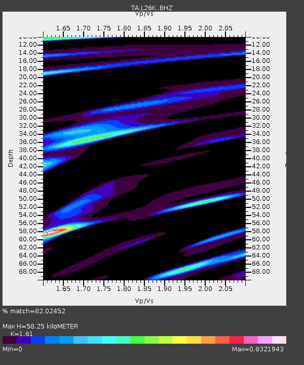
| Estimated Moho Depth: |
58.25 km |
| Estimated Crust Vp/Vs: |
1.61 |
| Assumed Crust Vp: |
6.566 km/s |
| Estimated Crust Vs: |
4.078 km/s |
| Estimated Crust Poisson's Ratio: |
0.19 |
|
| Radial Match: |
82.02452 % |
| Radial Bump: |
326 |
| Transverse Match: |
68.42025 % |
| Transverse Bump: |
400 |
| SOD ConfigId: |
7422571 |
| Insert Time: |
2019-04-22 09:50:18.460 +0000 |
| GWidth: |
2.5 |
| Max Bumps: |
400 |
| Tol: |
0.001 |
|

Signal To Noise
| Channel | StoN | STA | LTA |
| TA:L26K: :BHZ:20160420T08:45:11.174988Z | 3.309762 | 3.134498E-7 | 9.470463E-8 |
| TA:L26K: :BHN:20160420T08:45:11.174988Z | 1.4680263 | 1.1033185E-7 | 7.515659E-8 |
| TA:L26K: :BHE:20160420T08:45:11.174988Z | 1.9288975 | 1.3139643E-7 | 6.811997E-8 |
| Arrivals |
| Ps | 5.6 SECOND |
| PpPs | 22 SECOND |
| PsPs/PpSs | 28 SECOND |


