You are here: Home > Network List > TA - USArray Transportable Network (new EarthScope stations) Stations List
> Station M53A WI Miller and Sons, Farmdale, OH, USA > Earthquake Result Viewer
M53A WI Miller and Sons, Farmdale, OH, USA - Earthquake Result Viewer

| Earthquake location: |
Near Coast Of Ecuador |
| Earthquake latitude/longitude: |
0.6/-80.3 |
| Earthquake time(UTC): |
2016/04/20 (111) 08:33:48 GMT |
| Earthquake Depth: |
16 km |
| Earthquake Magnitude: |
6.1 MO |
| Earthquake Catalog/Contributor: |
NEIC PDE/NEIC ALERT |
|
| Network: |
TA USArray Transportable Network (new EarthScope stations) |
| Station: |
M53A WI Miller and Sons, Farmdale, OH, USA |
| Lat/Lon: |
41.44 N/80.68 W |
| Elevation: |
334 m |
|
| Distance: |
40.6 deg |
| Az: |
359.521 deg |
| Baz: |
179.363 deg |
| Ray Param: |
0.0742636 |
| Estimated Moho Depth: |
51.25 km |
| Estimated Crust Vp/Vs: |
1.75 |
| Assumed Crust Vp: |
6.483 km/s |
| Estimated Crust Vs: |
3.71 km/s |
| Estimated Crust Poisson's Ratio: |
0.26 |
|
| Radial Match: |
91.27283 % |
| Radial Bump: |
297 |
| Transverse Match: |
57.476826 % |
| Transverse Bump: |
400 |
| SOD ConfigId: |
7422571 |
| Insert Time: |
2019-04-22 09:50:29.812 +0000 |
| GWidth: |
2.5 |
| Max Bumps: |
400 |
| Tol: |
0.001 |
|
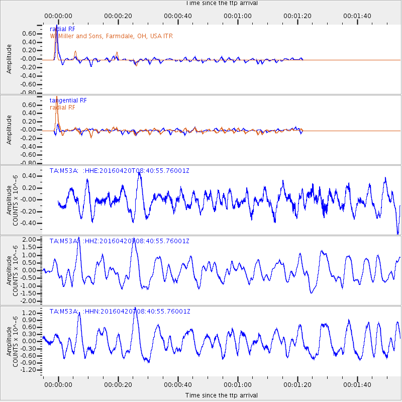
Signal To Noise
| Channel | StoN | STA | LTA |
| TA:M53A: :HHZ:20160420T08:40:55.76001Z | 3.3891783 | 5.538415E-7 | 1.634147E-7 |
| TA:M53A: :HHN:20160420T08:40:55.76001Z | 2.4404387 | 3.1402556E-7 | 1.2867586E-7 |
| TA:M53A: :HHE:20160420T08:40:55.76001Z | 0.77550536 | 1.1970737E-7 | 1.5436046E-7 |
| Arrivals |
| Ps | 6.4 SECOND |
| PpPs | 20 SECOND |
| PsPs/PpSs | 27 SECOND |


