You are here: Home > Network List > TA - USArray Transportable Network (new EarthScope stations) Stations List
> Station MSTX Muleshoe, TX, USA > Earthquake Result Viewer
MSTX Muleshoe, TX, USA - Earthquake Result Viewer

| Earthquake location: |
Near Coast Of Ecuador |
| Earthquake latitude/longitude: |
0.6/-80.3 |
| Earthquake time(UTC): |
2016/04/20 (111) 08:33:48 GMT |
| Earthquake Depth: |
16 km |
| Earthquake Magnitude: |
6.1 MO |
| Earthquake Catalog/Contributor: |
NEIC PDE/NEIC ALERT |
|
| Network: |
TA USArray Transportable Network (new EarthScope stations) |
| Station: |
MSTX Muleshoe, TX, USA |
| Lat/Lon: |
33.97 N/102.77 W |
| Elevation: |
1167 m |
|
| Distance: |
39.3 deg |
| Az: |
329.862 deg |
| Baz: |
142.835 deg |
| Ray Param: |
0.07503368 |
| Estimated Moho Depth: |
66.0 km |
| Estimated Crust Vp/Vs: |
2.03 |
| Assumed Crust Vp: |
6.129 km/s |
| Estimated Crust Vs: |
3.027 km/s |
| Estimated Crust Poisson's Ratio: |
0.34 |
|
| Radial Match: |
92.593506 % |
| Radial Bump: |
289 |
| Transverse Match: |
64.20485 % |
| Transverse Bump: |
400 |
| SOD ConfigId: |
7422571 |
| Insert Time: |
2019-04-22 09:50:31.038 +0000 |
| GWidth: |
2.5 |
| Max Bumps: |
400 |
| Tol: |
0.001 |
|
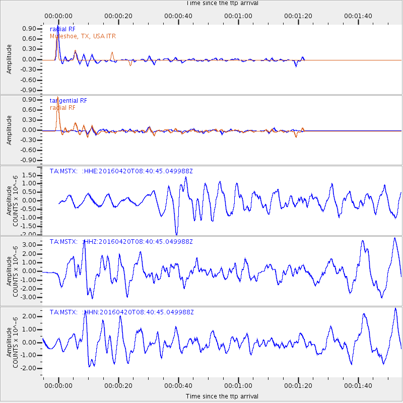
Signal To Noise
| Channel | StoN | STA | LTA |
| TA:MSTX: :HHZ:20160420T08:40:45.049988Z | 6.48213 | 1.0971379E-6 | 1.6925576E-7 |
| TA:MSTX: :HHN:20160420T08:40:45.049988Z | 2.2196805 | 3.8712892E-7 | 1.744075E-7 |
| TA:MSTX: :HHE:20160420T08:40:45.049988Z | 2.384131 | 5.3687063E-7 | 2.2518503E-7 |
| Arrivals |
| Ps | 12 SECOND |
| PpPs | 31 SECOND |
| PsPs/PpSs | 42 SECOND |


