You are here: Home > Network List > TD - TransAlta Monitoring Network Stations List
> Station TD029 Z > Earthquake Result Viewer
TD029 Z - Earthquake Result Viewer
| Earthquake location: |
Near Coast Of Ecuador |
| Earthquake latitude/longitude: |
0.6/-80.3 |
| Earthquake time(UTC): |
2016/04/20 (111) 08:33:48 GMT |
| Earthquake Depth: |
16 km |
| Earthquake Magnitude: |
6.1 MO |
| Earthquake Catalog/Contributor: |
NEIC PDE/NEIC ALERT |
|
| Network: |
TD TransAlta Monitoring Network |
| Station: |
TD029 Z |
| Lat/Lon: |
52.22 N/115.20 W |
| Elevation: |
1164 m |
|
| Distance: |
59.2 deg |
| Az: |
335.772 deg |
| Baz: |
138.166 deg |
| Ray Param: |
0.06235703 |
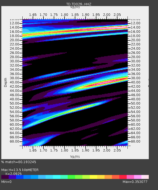
| Estimated Moho Depth: |
13.5 km |
| Estimated Crust Vp/Vs: |
2.09 |
| Assumed Crust Vp: |
6.426 km/s |
| Estimated Crust Vs: |
3.071 km/s |
| Estimated Crust Poisson's Ratio: |
0.35 |
|
| Radial Match: |
80.193245 % |
| Radial Bump: |
355 |
| Transverse Match: |
65.89011 % |
| Transverse Bump: |
391 |
| SOD ConfigId: |
7422571 |
| Insert Time: |
2019-04-22 09:51:00.996 +0000 |
| GWidth: |
2.5 |
| Max Bumps: |
400 |
| Tol: |
0.001 |
|

Signal To Noise
| Channel | StoN | STA | LTA |
| TD:TD029: :HHZ:20160420T08:43:16.409973Z | 4.2043447 | 5.434958E-7 | 1.2927003E-7 |
| TD:TD029: :HH1:20160420T08:43:16.409973Z | 2.2421775 | 4.6979844E-7 | 2.0952777E-7 |
| TD:TD029: :HH2:20160420T08:43:16.409973Z | 1.4232464 | 3.06498E-7 | 2.1535135E-7 |
| Arrivals |
| Ps | 2.4 SECOND |
| PpPs | 6.2 SECOND |
| PsPs/PpSs | 8.6 SECOND |


