You are here: Home > Network List > UW - Pacific Northwest Regional Seismic Network Stations List
> Station KENT Carlson Farm, Grass Valley, OR, USA > Earthquake Result Viewer
KENT Carlson Farm, Grass Valley, OR, USA - Earthquake Result Viewer
| Earthquake location: |
Near Coast Of Ecuador |
| Earthquake latitude/longitude: |
0.6/-80.3 |
| Earthquake time(UTC): |
2016/04/20 (111) 08:33:48 GMT |
| Earthquake Depth: |
16 km |
| Earthquake Magnitude: |
6.1 MO |
| Earthquake Catalog/Contributor: |
NEIC PDE/NEIC ALERT |
|
| Network: |
UW Pacific Northwest Regional Seismic Network |
| Station: |
KENT Carlson Farm, Grass Valley, OR, USA |
| Lat/Lon: |
45.24 N/120.64 W |
| Elevation: |
780 m |
|
| Distance: |
56.9 deg |
| Az: |
326.894 deg |
| Baz: |
129.378 deg |
| Ray Param: |
0.063806765 |
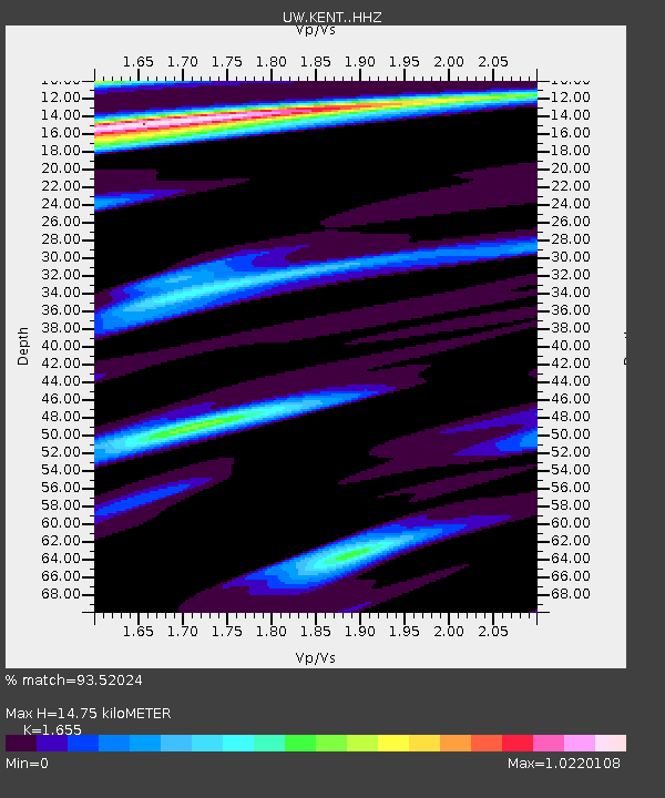
| Estimated Moho Depth: |
14.75 km |
| Estimated Crust Vp/Vs: |
1.65 |
| Assumed Crust Vp: |
6.597 km/s |
| Estimated Crust Vs: |
3.986 km/s |
| Estimated Crust Poisson's Ratio: |
0.21 |
|
| Radial Match: |
93.52024 % |
| Radial Bump: |
263 |
| Transverse Match: |
84.03694 % |
| Transverse Bump: |
323 |
| SOD ConfigId: |
7422571 |
| Insert Time: |
2019-04-22 09:51:22.450 +0000 |
| GWidth: |
2.5 |
| Max Bumps: |
400 |
| Tol: |
0.001 |
|
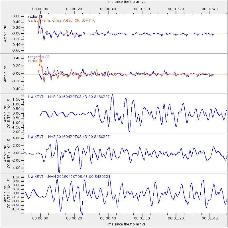
Signal To Noise
| Channel | StoN | STA | LTA |
| UW:KENT: :HHZ:20160420T08:43:00.848022Z | 6.2015877 | 1.0904101E-6 | 1.758276E-7 |
| UW:KENT: :HHN:20160420T08:43:00.848022Z | 1.483377 | 2.2780527E-7 | 1.5357207E-7 |
| UW:KENT: :HHE:20160420T08:43:00.848022Z | 2.6348326 | 4.491387E-7 | 1.7046195E-7 |
| Arrivals |
| Ps | 1.6 SECOND |
| PpPs | 5.6 SECOND |
| PsPs/PpSs | 7.2 SECOND |


