You are here: Home > Network List > CI - Caltech Regional Seismic Network Stations List
> Station DEC Green Verdugo Microwave Site, Sunland, CA, USA > Earthquake Result Viewer
DEC Green Verdugo Microwave Site, Sunland, CA, USA - Earthquake Result Viewer

| Earthquake location: |
Vanuatu Islands |
| Earthquake latitude/longitude: |
-13.0/166.5 |
| Earthquake time(UTC): |
2009/10/07 (280) 22:03:14 GMT |
| Earthquake Depth: |
45 km |
| Earthquake Magnitude: |
6.4 MB, 7.3 MS, 7.6 MW, 7.7 MW |
| Earthquake Catalog/Contributor: |
WHDF/NEIC |
|
| Network: |
CI Caltech Regional Seismic Network |
| Station: |
DEC Green Verdugo Microwave Site, Sunland, CA, USA |
| Lat/Lon: |
34.25 N/118.33 W |
| Elevation: |
519 m |
|
| Distance: |
85.3 deg |
| Az: |
53.45 deg |
| Baz: |
250.961 deg |
| Ray Param: |
0.044774335 |
| Estimated Moho Depth: |
40.75 km |
| Estimated Crust Vp/Vs: |
1.60 |
| Assumed Crust Vp: |
6.1 km/s |
| Estimated Crust Vs: |
3.807 km/s |
| Estimated Crust Poisson's Ratio: |
0.18 |
|
| Radial Match: |
91.23571 % |
| Radial Bump: |
400 |
| Transverse Match: |
79.51049 % |
| Transverse Bump: |
400 |
| SOD ConfigId: |
2622 |
| Insert Time: |
2010-02-26 00:18:02.992 +0000 |
| GWidth: |
2.5 |
| Max Bumps: |
400 |
| Tol: |
0.001 |
|
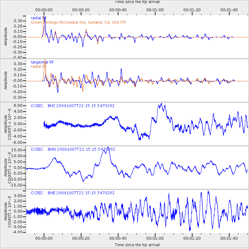
Signal To Noise
| Channel | StoN | STA | LTA |
| CI:DEC: :BHN:20091007T22:15:15.547026Z | 9.373843 | 3.2610365E-6 | 3.4788684E-7 |
| CI:DEC: :BHE:20091007T22:15:15.547026Z | 0.9026934 | 4.1010165E-7 | 4.5430892E-7 |
| CI:DEC: :BHZ:20091007T22:15:15.547026Z | 1.9284047 | 1.062323E-6 | 5.508818E-7 |
| Arrivals |
| Ps | 4.1 SECOND |
| PpPs | 17 SECOND |
| PsPs/PpSs | 21 SECOND |


