You are here: Home > Network List > XD14 - Illuminating the architecture of the greater Mount St. Helens magmatic systems f Stations List
> Station MH09 "Mount St Helens, WA" > Earthquake Result Viewer
MH09 "Mount St Helens, WA" - Earthquake Result Viewer
| Earthquake location: |
Near Coast Of Ecuador |
| Earthquake latitude/longitude: |
0.6/-80.3 |
| Earthquake time(UTC): |
2016/04/20 (111) 08:33:48 GMT |
| Earthquake Depth: |
16 km |
| Earthquake Magnitude: |
6.1 MO |
| Earthquake Catalog/Contributor: |
NEIC PDE/NEIC ALERT |
|
| Network: |
XD Illuminating the architecture of the greater Mount St. Helens magmatic systems f |
| Station: |
MH09 "Mount St Helens, WA" |
| Lat/Lon: |
46.30 N/121.80 W |
| Elevation: |
989 m |
|
| Distance: |
58.2 deg |
| Az: |
327.262 deg |
| Baz: |
128.743 deg |
| Ray Param: |
0.06296577 |
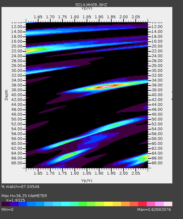
| Estimated Moho Depth: |
36.25 km |
| Estimated Crust Vp/Vs: |
1.93 |
| Assumed Crust Vp: |
6.597 km/s |
| Estimated Crust Vs: |
3.414 km/s |
| Estimated Crust Poisson's Ratio: |
0.32 |
|
| Radial Match: |
87.04546 % |
| Radial Bump: |
400 |
| Transverse Match: |
60.29463 % |
| Transverse Bump: |
400 |
| SOD ConfigId: |
7422571 |
| Insert Time: |
2019-04-22 09:52:18.362 +0000 |
| GWidth: |
2.5 |
| Max Bumps: |
400 |
| Tol: |
0.001 |
|

Signal To Noise
| Channel | StoN | STA | LTA |
| XD:MH09: :BHZ:20160420T08:43:10.005005Z | 6.04218 | 5.3643197E-7 | 8.878119E-8 |
| XD:MH09: :BHN:20160420T08:43:10.005005Z | 1.2388428 | 1.9356382E-7 | 1.5624566E-7 |
| XD:MH09: :BHE:20160420T08:43:10.005005Z | 1.9411799 | 2.2521117E-7 | 1.16017674E-7 |
| Arrivals |
| Ps | 5.4 SECOND |
| PpPs | 15 SECOND |
| PsPs/PpSs | 21 SECOND |


