You are here: Home > Network List > XD14 - Illuminating the architecture of the greater Mount St. Helens magmatic systems f Stations List
> Station MI05 "Mount St Helens, WA" > Earthquake Result Viewer
MI05 "Mount St Helens, WA" - Earthquake Result Viewer
| Earthquake location: |
Near Coast Of Ecuador |
| Earthquake latitude/longitude: |
0.6/-80.3 |
| Earthquake time(UTC): |
2016/04/20 (111) 08:33:48 GMT |
| Earthquake Depth: |
16 km |
| Earthquake Magnitude: |
6.1 MO |
| Earthquake Catalog/Contributor: |
NEIC PDE/NEIC ALERT |
|
| Network: |
XD Illuminating the architecture of the greater Mount St. Helens magmatic systems f |
| Station: |
MI05 "Mount St Helens, WA" |
| Lat/Lon: |
46.23 N/122.29 W |
| Elevation: |
1255 m |
|
| Distance: |
58.5 deg |
| Az: |
326.951 deg |
| Baz: |
128.226 deg |
| Ray Param: |
0.06281897 |
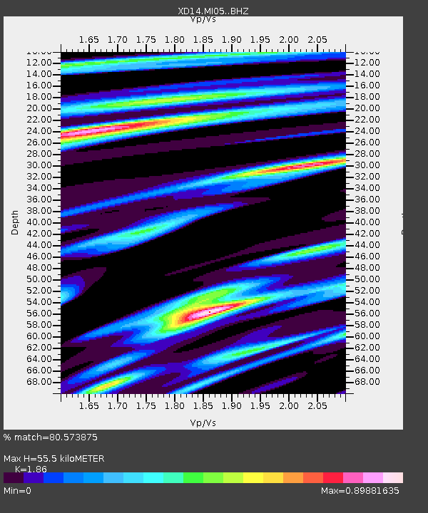
| Estimated Moho Depth: |
55.5 km |
| Estimated Crust Vp/Vs: |
1.86 |
| Assumed Crust Vp: |
6.566 km/s |
| Estimated Crust Vs: |
3.53 km/s |
| Estimated Crust Poisson's Ratio: |
0.30 |
|
| Radial Match: |
80.573875 % |
| Radial Bump: |
400 |
| Transverse Match: |
61.093273 % |
| Transverse Bump: |
398 |
| SOD ConfigId: |
7422571 |
| Insert Time: |
2019-04-22 09:52:19.887 +0000 |
| GWidth: |
2.5 |
| Max Bumps: |
400 |
| Tol: |
0.001 |
|

Signal To Noise
| Channel | StoN | STA | LTA |
| XD:MI05: :BHZ:20160420T08:43:11.565002Z | 2.0686169 | 4.3052364E-7 | 2.081215E-7 |
| XD:MI05: :BHN:20160420T08:43:11.565002Z | 1.4022788 | 1.8620827E-7 | 1.3278976E-7 |
| XD:MI05: :BHE:20160420T08:43:11.565002Z | 0.64343816 | 1.334738E-7 | 2.0743843E-7 |
| Arrivals |
| Ps | 7.6 SECOND |
| PpPs | 23 SECOND |
| PsPs/PpSs | 31 SECOND |


