You are here: Home > Network List > XD14 - Illuminating the architecture of the greater Mount St. Helens magmatic systems f Stations List
> Station MQ07 "Mount St Helens, WA" > Earthquake Result Viewer
MQ07 "Mount St Helens, WA" - Earthquake Result Viewer
| Earthquake location: |
Near Coast Of Ecuador |
| Earthquake latitude/longitude: |
0.6/-80.3 |
| Earthquake time(UTC): |
2016/04/20 (111) 08:33:48 GMT |
| Earthquake Depth: |
16 km |
| Earthquake Magnitude: |
6.1 MO |
| Earthquake Catalog/Contributor: |
NEIC PDE/NEIC ALERT |
|
| Network: |
XD Illuminating the architecture of the greater Mount St. Helens magmatic systems f |
| Station: |
MQ07 "Mount St Helens, WA" |
| Lat/Lon: |
45.81 N/122.11 W |
| Elevation: |
1037 m |
|
| Distance: |
58.1 deg |
| Az: |
326.654 deg |
| Baz: |
128.203 deg |
| Ray Param: |
0.06305549 |
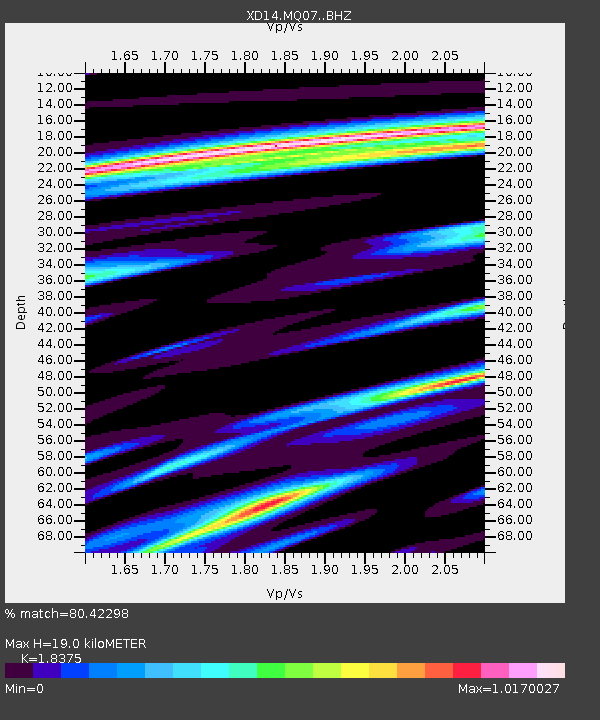
| Estimated Moho Depth: |
19.0 km |
| Estimated Crust Vp/Vs: |
1.84 |
| Assumed Crust Vp: |
6.566 km/s |
| Estimated Crust Vs: |
3.573 km/s |
| Estimated Crust Poisson's Ratio: |
0.29 |
|
| Radial Match: |
80.42298 % |
| Radial Bump: |
400 |
| Transverse Match: |
60.71407 % |
| Transverse Bump: |
400 |
| SOD ConfigId: |
7422571 |
| Insert Time: |
2019-04-22 09:52:43.629 +0000 |
| GWidth: |
2.5 |
| Max Bumps: |
400 |
| Tol: |
0.001 |
|

Signal To Noise
| Channel | StoN | STA | LTA |
| XD:MQ07: :BHZ:20160420T08:43:09.049988Z | 8.485186 | 6.311463E-7 | 7.438214E-8 |
| XD:MQ07: :BHN:20160420T08:43:09.049988Z | 1.9942627 | 2.1416267E-7 | 1.073894E-7 |
| XD:MQ07: :BHE:20160420T08:43:09.049988Z | 3.8760607 | 4.241256E-7 | 1.0942181E-7 |
| Arrivals |
| Ps | 2.5 SECOND |
| PpPs | 7.8 SECOND |
| PsPs/PpSs | 10 SECOND |


