You are here: Home > Network List > 7A - Mid-Atlantic Geophysical Integrative Collaboration Stations List
> Station NAZF Center Point, West Virginia USA > Earthquake Result Viewer
NAZF Center Point, West Virginia USA - Earthquake Result Viewer
| Earthquake location: |
Near Coast Of Ecuador |
| Earthquake latitude/longitude: |
0.7/-80.0 |
| Earthquake time(UTC): |
2016/04/20 (111) 08:35:10 GMT |
| Earthquake Depth: |
10 km |
| Earthquake Magnitude: |
6.0 MWB |
| Earthquake Catalog/Contributor: |
NEIC PDE/NEIC COMCAT |
|
| Network: |
7A Mid-Atlantic Geophysical Integrative Collaboration |
| Station: |
NAZF Center Point, West Virginia USA |
| Lat/Lon: |
39.38 N/80.64 W |
| Elevation: |
0.0 m |
|
| Distance: |
38.5 deg |
| Az: |
359.215 deg |
| Baz: |
178.987 deg |
| Ray Param: |
0.07553116 |
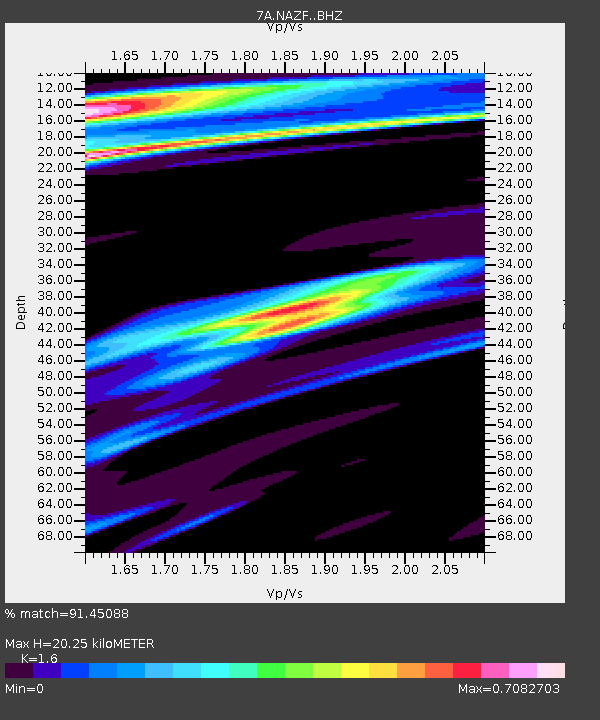
| Estimated Moho Depth: |
20.25 km |
| Estimated Crust Vp/Vs: |
1.60 |
| Assumed Crust Vp: |
6.207 km/s |
| Estimated Crust Vs: |
3.879 km/s |
| Estimated Crust Poisson's Ratio: |
0.18 |
|
| Radial Match: |
91.45088 % |
| Radial Bump: |
273 |
| Transverse Match: |
69.16366 % |
| Transverse Bump: |
400 |
| SOD ConfigId: |
7422571 |
| Insert Time: |
2019-04-22 09:54:34.173 +0000 |
| GWidth: |
2.5 |
| Max Bumps: |
400 |
| Tol: |
0.001 |
|

Signal To Noise
| Channel | StoN | STA | LTA |
| 7A:NAZF: :BHZ:20160420T08:42:02.005004Z | 1.8446232 | 1.0407567E-6 | 5.64211E-7 |
| 7A:NAZF: :BHN:20160420T08:42:02.005004Z | 2.3329744 | 7.6857697E-7 | 3.294408E-7 |
| 7A:NAZF: :BHE:20160420T08:42:02.005004Z | 0.5894793 | 9.931588E-8 | 1.684807E-7 |
| Arrivals |
| Ps | 2.1 SECOND |
| PpPs | 7.9 SECOND |
| PsPs/PpSs | 10.0 SECOND |


