You are here: Home > Network List > N4 - Central and EAstern US Network Stations List
> Station X51A Calhoun, GA, USA > Earthquake Result Viewer
X51A Calhoun, GA, USA - Earthquake Result Viewer
| Earthquake location: |
Near Coast Of Ecuador |
| Earthquake latitude/longitude: |
0.7/-80.0 |
| Earthquake time(UTC): |
2016/04/20 (111) 08:35:10 GMT |
| Earthquake Depth: |
10 km |
| Earthquake Magnitude: |
6.0 MWB |
| Earthquake Catalog/Contributor: |
NEIC PDE/NEIC COMCAT |
|
| Network: |
N4 Central and EAstern US Network |
| Station: |
X51A Calhoun, GA, USA |
| Lat/Lon: |
34.57 N/84.86 W |
| Elevation: |
214 m |
|
| Distance: |
34.0 deg |
| Az: |
352.832 deg |
| Baz: |
171.305 deg |
| Ray Param: |
0.07795556 |
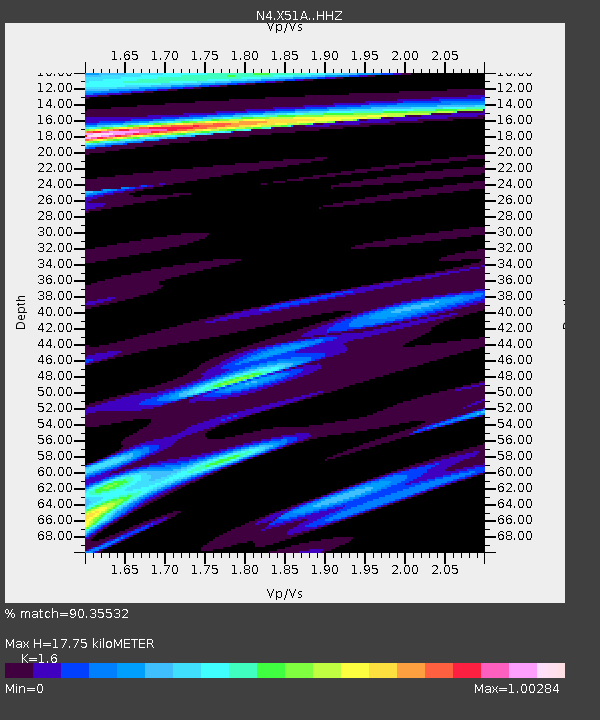
| Estimated Moho Depth: |
17.75 km |
| Estimated Crust Vp/Vs: |
1.60 |
| Assumed Crust Vp: |
6.35 km/s |
| Estimated Crust Vs: |
3.969 km/s |
| Estimated Crust Poisson's Ratio: |
0.18 |
|
| Radial Match: |
90.35532 % |
| Radial Bump: |
300 |
| Transverse Match: |
69.88679 % |
| Transverse Bump: |
400 |
| SOD ConfigId: |
7422571 |
| Insert Time: |
2019-04-22 09:58:32.940 +0000 |
| GWidth: |
2.5 |
| Max Bumps: |
400 |
| Tol: |
0.001 |
|

Signal To Noise
| Channel | StoN | STA | LTA |
| N4:X51A: :HHZ:20160420T08:41:23.540007Z | 2.304969 | 1.2708665E-6 | 5.5135945E-7 |
| N4:X51A: :HHN:20160420T08:41:23.540007Z | 2.3703892 | 1.0606906E-6 | 4.4747526E-7 |
| N4:X51A: :HHE:20160420T08:41:23.540007Z | 1.0397882 | 2.2853312E-7 | 2.1978812E-7 |
| Arrivals |
| Ps | 1.8 SECOND |
| PpPs | 6.7 SECOND |
| PsPs/PpSs | 8.5 SECOND |


