You are here: Home > Network List > CI - Caltech Regional Seismic Network Stations List
> Station SWS Sam W. Stewart, Westmorland, CA, USA > Earthquake Result Viewer
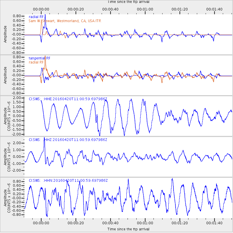
SWS Sam W. Stewart, Westmorland, CA, USA - Earthquake Result Viewer
*The percent match for this event was below the threshold and hence no stack was calculated.
| Earthquake location: |
North Atlantic Ocean |
| Earthquake latitude/longitude: |
13.2/-55.9 |
| Earthquake time(UTC): |
2016/04/20 (111) 10:51:39 GMT |
| Earthquake Depth: |
10 km |
| Earthquake Magnitude: |
5.8 MB |
| Earthquake Catalog/Contributor: |
NEIC PDE/NEIC COMCAT |
|
| Network: |
CI Caltech Regional Seismic Network |
| Station: |
SWS Sam W. Stewart, Westmorland, CA, USA |
| Lat/Lon: |
32.94 N/115.80 W |
| Elevation: |
140 m |
|
| Distance: |
57.7 deg |
| Az: |
300.668 deg |
| Baz: |
95.002 deg |
| Ray Param: |
$rayparam |
*The percent match for this event was below the threshold and hence was not used in the summary stack. |
|
| Radial Match: |
85.33685 % |
| Radial Bump: |
400 |
| Transverse Match: |
90.022766 % |
| Transverse Bump: |
400 |
| SOD ConfigId: |
7422571 |
| Insert Time: |
2019-04-22 10:05:07.950 +0000 |
| GWidth: |
2.5 |
| Max Bumps: |
400 |
| Tol: |
0.001 |
|
Signal To Noise
| Channel | StoN | STA | LTA |
| CI:SWS: :HHZ:20160420T11:00:59.697986Z | 1.5503393 | 1.0454935E-6 | 6.7436434E-7 |
| CI:SWS: :HHN:20160420T11:00:59.697986Z | 1.3428273 | 4.4410845E-7 | 3.3072638E-7 |
| CI:SWS: :HHE:20160420T11:00:59.697986Z | 1.4853842 | 1.2985719E-6 | 8.7423297E-7 |
| Arrivals |
| Ps | |
| PpPs | |
| PsPs/PpSs | |


