You are here: Home > Network List > US - United States National Seismic Network Stations List
> Station WMOK Wichita Mountains, Oklahoma, USA > Earthquake Result Viewer
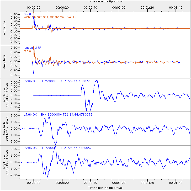
WMOK Wichita Mountains, Oklahoma, USA - Earthquake Result Viewer

| Earthquake location: |
Sakhalin, Russia |
| Earthquake latitude/longitude: |
48.8/142.2 |
| Earthquake time(UTC): |
2000/08/04 (217) 21:13:02 GMT |
| Earthquake Depth: |
10 km |
| Earthquake Magnitude: |
6.3 MB, 7.1 MS, 6.8 MW, 6.7 MW |
| Earthquake Catalog/Contributor: |
WHDF/NEIC |
|
| Network: |
US United States National Seismic Network |
| Station: |
WMOK Wichita Mountains, Oklahoma, USA |
| Lat/Lon: |
34.74 N/98.78 W |
| Elevation: |
486 m |
|
| Distance: |
80.7 deg |
| Az: |
46.893 deg |
| Baz: |
324.104 deg |
| Ray Param: |
0.048099235 |
| Estimated Moho Depth: |
29.0 km |
| Estimated Crust Vp/Vs: |
1.60 |
| Assumed Crust Vp: |
6.315 km/s |
| Estimated Crust Vs: |
3.947 km/s |
| Estimated Crust Poisson's Ratio: |
0.18 |
|
| Radial Match: |
97.68526 % |
| Radial Bump: |
335 |
| Transverse Match: |
91.02755 % |
| Transverse Bump: |
400 |
| SOD ConfigId: |
110165 |
| Insert Time: |
2010-03-05 01:59:35.983 +0000 |
| GWidth: |
2.5 |
| Max Bumps: |
400 |
| Tol: |
0.001 |
|
Signal To Noise
| Channel | StoN | STA | LTA |
| US:WMOK: :BHN:20000804T21:24:44.478005Z | 4.8377194 | 3.1860864E-7 | 6.585927E-8 |
| US:WMOK: :BHE:20000804T21:24:44.478005Z | 7.3355684 | 5.299924E-7 | 7.224967E-8 |
| US:WMOK: :BHZ:20000804T21:24:44.48002Z | 62.114067 | 2.0911434E-6 | 3.366618E-8 |
| Arrivals |
| Ps | 2.8 SECOND |
| PpPs | 12 SECOND |
| PsPs/PpSs | 14 SECOND |


