You are here: Home > Network List > US - United States National Seismic Network Stations List
> Station WMOK Wichita Mountains, Oklahoma, USA > Earthquake Result Viewer
WMOK Wichita Mountains, Oklahoma, USA - Earthquake Result Viewer
| Earthquake location: |
South Of Alaska |
| Earthquake latitude/longitude: |
53.8/-161.1 |
| Earthquake time(UTC): |
2002/05/25 (145) 05:36:31 GMT |
| Earthquake Depth: |
33 km |
| Earthquake Magnitude: |
5.5 MB, 6.1 MS, 6.5 MW, 6.4 MW |
| Earthquake Catalog/Contributor: |
WHDF/NEIC |
|
| Network: |
US United States National Seismic Network |
| Station: |
WMOK Wichita Mountains, Oklahoma, USA |
| Lat/Lon: |
34.74 N/98.78 W |
| Elevation: |
486 m |
|
| Distance: |
46.9 deg |
| Az: |
87.765 deg |
| Baz: |
313.989 deg |
| Ray Param: |
0.07029236 |
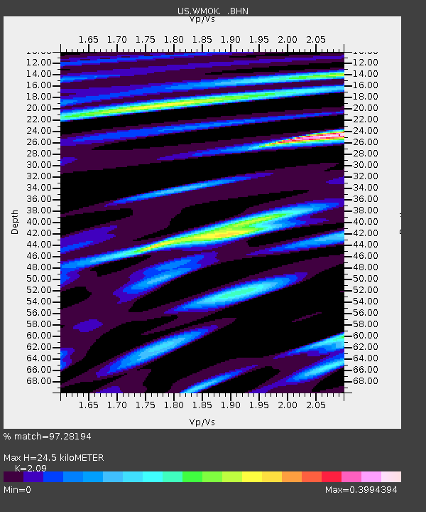
| Estimated Moho Depth: |
24.5 km |
| Estimated Crust Vp/Vs: |
2.09 |
| Assumed Crust Vp: |
6.315 km/s |
| Estimated Crust Vs: |
3.022 km/s |
| Estimated Crust Poisson's Ratio: |
0.35 |
|
| Radial Match: |
97.28194 % |
| Radial Bump: |
336 |
| Transverse Match: |
97.30788 % |
| Transverse Bump: |
341 |
| SOD ConfigId: |
110177 |
| Insert Time: |
2010-03-05 01:59:42.898 +0000 |
| GWidth: |
2.5 |
| Max Bumps: |
400 |
| Tol: |
0.001 |
|
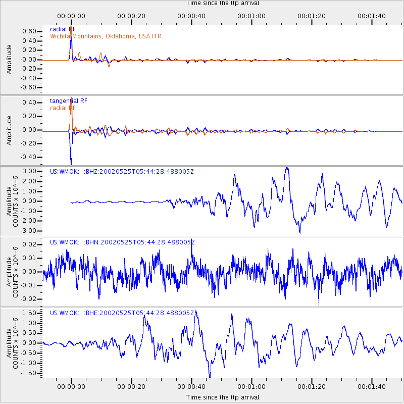
Signal To Noise
| Channel | StoN | STA | LTA |
| US:WMOK: :BHN:20020525T05:44:28.488005Z | 1.4791329 | 7.820471E-9 | 5.2872E-9 |
| US:WMOK: :BHE:20020525T05:44:28.488005Z | 1.8047065 | 1.0307946E-7 | 5.711702E-8 |
| US:WMOK: :BHZ:20020525T05:44:28.488005Z | 3.5647855 | 2.0020431E-7 | 5.616167E-8 |
| Arrivals |
| Ps | 4.4 SECOND |
| PpPs | 11 SECOND |
| PsPs/PpSs | 16 SECOND |


