You are here: Home > Network List > US - United States National Seismic Network Stations List
> Station WMOK Wichita Mountains, Oklahoma, USA > Earthquake Result Viewer
WMOK Wichita Mountains, Oklahoma, USA - Earthquake Result Viewer

| Earthquake location: |
Near Coast Of Central Chile |
| Earthquake latitude/longitude: |
-30.8/-71.1 |
| Earthquake time(UTC): |
2002/06/18 (169) 13:56:22 GMT |
| Earthquake Depth: |
54 km |
| Earthquake Magnitude: |
6.0 MB, 6.6 MW, 6.4 MW |
| Earthquake Catalog/Contributor: |
WHDF/NEIC |
|
| Network: |
US United States National Seismic Network |
| Station: |
WMOK Wichita Mountains, Oklahoma, USA |
| Lat/Lon: |
34.74 N/98.78 W |
| Elevation: |
486 m |
|
| Distance: |
70.2 deg |
| Az: |
336.029 deg |
| Baz: |
154.884 deg |
| Ray Param: |
0.055023115 |
| Estimated Moho Depth: |
23.75 km |
| Estimated Crust Vp/Vs: |
1.71 |
| Assumed Crust Vp: |
6.315 km/s |
| Estimated Crust Vs: |
3.704 km/s |
| Estimated Crust Poisson's Ratio: |
0.24 |
|
| Radial Match: |
94.737854 % |
| Radial Bump: |
400 |
| Transverse Match: |
95.43167 % |
| Transverse Bump: |
400 |
| SOD ConfigId: |
110177 |
| Insert Time: |
2010-03-05 01:59:47.039 +0000 |
| GWidth: |
2.5 |
| Max Bumps: |
400 |
| Tol: |
0.001 |
|
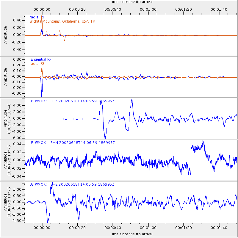
Signal To Noise
| Channel | StoN | STA | LTA |
| US:WMOK: :BHN:20020618T14:06:59.186995Z | 1.1624043 | 1.0875977E-8 | 9.356449E-9 |
| US:WMOK: :BHE:20020618T14:06:59.186995Z | 12.291383 | 7.30717E-7 | 5.9449533E-8 |
| US:WMOK: :BHZ:20020618T14:06:59.186995Z | 58.751175 | 2.6264067E-6 | 4.4703903E-8 |
| Arrivals |
| Ps | 2.8 SECOND |
| PpPs | 9.8 SECOND |
| PsPs/PpSs | 13 SECOND |


