You are here: Home > Network List > US - United States National Seismic Network Stations List
> Station WMOK Wichita Mountains, Oklahoma, USA > Earthquake Result Viewer
WMOK Wichita Mountains, Oklahoma, USA - Earthquake Result Viewer
| Earthquake location: |
North Atlantic Ocean |
| Earthquake latitude/longitude: |
18.3/-58.6 |
| Earthquake time(UTC): |
2003/05/14 (134) 06:03:35 GMT |
| Earthquake Depth: |
42 km |
| Earthquake Magnitude: |
6.5 MB, 6.5 MS, 6.6 MW, 6.6 MW |
| Earthquake Catalog/Contributor: |
WHDF/NEIC |
|
| Network: |
US United States National Seismic Network |
| Station: |
WMOK Wichita Mountains, Oklahoma, USA |
| Lat/Lon: |
34.74 N/98.78 W |
| Elevation: |
486 m |
|
| Distance: |
39.2 deg |
| Az: |
302.853 deg |
| Baz: |
104.236 deg |
| Ray Param: |
0.07502405 |
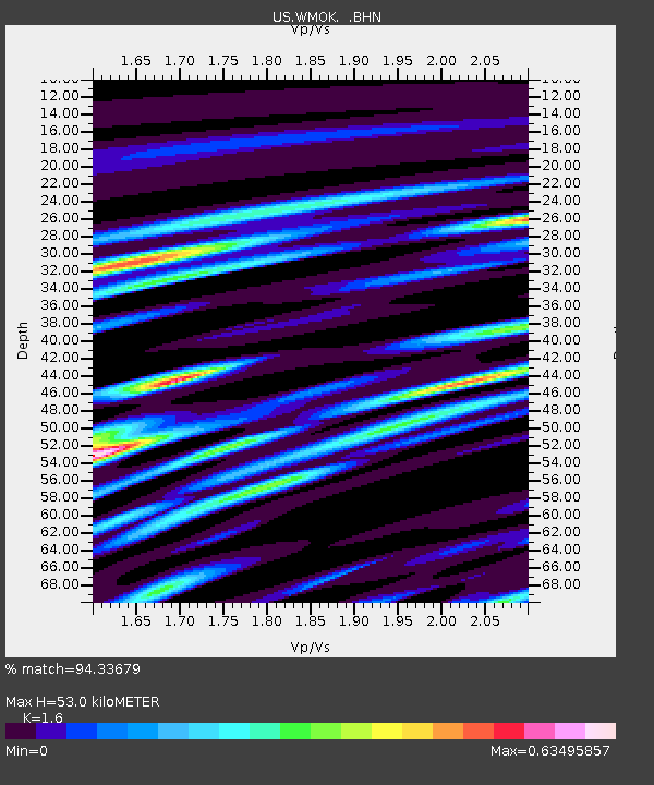
| Estimated Moho Depth: |
53.0 km |
| Estimated Crust Vp/Vs: |
1.60 |
| Assumed Crust Vp: |
6.315 km/s |
| Estimated Crust Vs: |
3.947 km/s |
| Estimated Crust Poisson's Ratio: |
0.18 |
|
| Radial Match: |
94.33679 % |
| Radial Bump: |
396 |
| Transverse Match: |
84.78535 % |
| Transverse Bump: |
400 |
| SOD ConfigId: |
110177 |
| Insert Time: |
2010-03-05 02:00:15.013 +0000 |
| GWidth: |
2.5 |
| Max Bumps: |
400 |
| Tol: |
0.001 |
|

Signal To Noise
| Channel | StoN | STA | LTA |
| US:WMOK: :BHN:20030514T06:10:29.577987Z | 2.5505896 | 1.6963803E-7 | 6.650934E-8 |
| US:WMOK: :BHE:20030514T06:10:29.577987Z | 11.324683 | 6.923078E-7 | 6.1132646E-8 |
| US:WMOK: :BHZ:20030514T06:10:29.577987Z | 29.951048 | 1.315319E-6 | 4.3915623E-8 |
| Arrivals |
| Ps | 5.4 SECOND |
| PpPs | 20 SECOND |
| PsPs/PpSs | 26 SECOND |


