You are here: Home > Network List > TA - USArray Transportable Network (new EarthScope stations) Stations List
> Station 833A Chaparral WMA, Artesia Wells, TX, USA > Earthquake Result Viewer
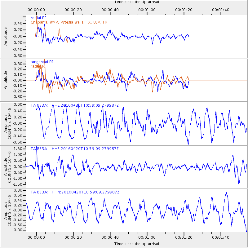
833A Chaparral WMA, Artesia Wells, TX, USA - Earthquake Result Viewer
*The percent match for this event was below the threshold and hence no stack was calculated.
| Earthquake location: |
North Atlantic Ocean |
| Earthquake latitude/longitude: |
13.2/-55.9 |
| Earthquake time(UTC): |
2016/04/20 (111) 10:51:39 GMT |
| Earthquake Depth: |
10 km |
| Earthquake Magnitude: |
5.8 MB |
| Earthquake Catalog/Contributor: |
NEIC PDE/NEIC COMCAT |
|
| Network: |
TA USArray Transportable Network (new EarthScope stations) |
| Station: |
833A Chaparral WMA, Artesia Wells, TX, USA |
| Lat/Lon: |
28.32 N/99.39 W |
| Elevation: |
171 m |
|
| Distance: |
43.1 deg |
| Az: |
297.405 deg |
| Baz: |
101.27 deg |
| Ray Param: |
$rayparam |
*The percent match for this event was below the threshold and hence was not used in the summary stack. |
|
| Radial Match: |
72.99326 % |
| Radial Bump: |
370 |
| Transverse Match: |
55.80841 % |
| Transverse Bump: |
284 |
| SOD ConfigId: |
7422571 |
| Insert Time: |
2019-04-22 10:10:32.978 +0000 |
| GWidth: |
2.5 |
| Max Bumps: |
400 |
| Tol: |
0.001 |
|
Signal To Noise
| Channel | StoN | STA | LTA |
| TA:833A: :HHZ:20160420T10:59:09.279987Z | 2.8222263 | 6.165373E-7 | 2.1845779E-7 |
| TA:833A: :HHN:20160420T10:59:09.279987Z | 1.292683 | 2.3333288E-7 | 1.8050278E-7 |
| TA:833A: :HHE:20160420T10:59:09.279987Z | 0.6658881 | 2.4490532E-7 | 3.6778752E-7 |
| Arrivals |
| Ps | |
| PpPs | |
| PsPs/PpSs | |


