You are here: Home > Network List > TA - USArray Transportable Network (new EarthScope stations) Stations List
> Station S22A 4UR Ranch, Creede, CO, USA > Earthquake Result Viewer
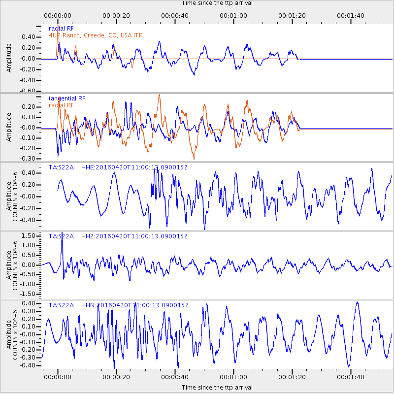
S22A 4UR Ranch, Creede, CO, USA - Earthquake Result Viewer
*The percent match for this event was below the threshold and hence no stack was calculated.
| Earthquake location: |
North Atlantic Ocean |
| Earthquake latitude/longitude: |
13.2/-55.9 |
| Earthquake time(UTC): |
2016/04/20 (111) 10:51:39 GMT |
| Earthquake Depth: |
10 km |
| Earthquake Magnitude: |
5.8 MB |
| Earthquake Catalog/Contributor: |
NEIC PDE/NEIC COMCAT |
|
| Network: |
TA USArray Transportable Network (new EarthScope stations) |
| Station: |
S22A 4UR Ranch, Creede, CO, USA |
| Lat/Lon: |
37.75 N/106.83 W |
| Elevation: |
2626 m |
|
| Distance: |
51.3 deg |
| Az: |
307.975 deg |
| Baz: |
104.43 deg |
| Ray Param: |
$rayparam |
*The percent match for this event was below the threshold and hence was not used in the summary stack. |
|
| Radial Match: |
76.28811 % |
| Radial Bump: |
400 |
| Transverse Match: |
68.83493 % |
| Transverse Bump: |
400 |
| SOD ConfigId: |
7422571 |
| Insert Time: |
2019-04-22 10:11:23.195 +0000 |
| GWidth: |
2.5 |
| Max Bumps: |
400 |
| Tol: |
0.001 |
|
Signal To Noise
| Channel | StoN | STA | LTA |
| TA:S22A: :HHZ:20160420T11:00:13.090015Z | 6.0319366 | 5.060138E-7 | 8.388911E-8 |
| TA:S22A: :HHN:20160420T11:00:13.090015Z | 0.64764804 | 1.1090189E-7 | 1.712379E-7 |
| TA:S22A: :HHE:20160420T11:00:13.090015Z | 1.6281754 | 2.9396142E-7 | 1.8054654E-7 |
| Arrivals |
| Ps | |
| PpPs | |
| PsPs/PpSs | |


