You are here: Home > Network List > UW - Pacific Northwest Regional Seismic Network Stations List
> Station WOLL Wollman Farm, Schrag, WA, USA > Earthquake Result Viewer
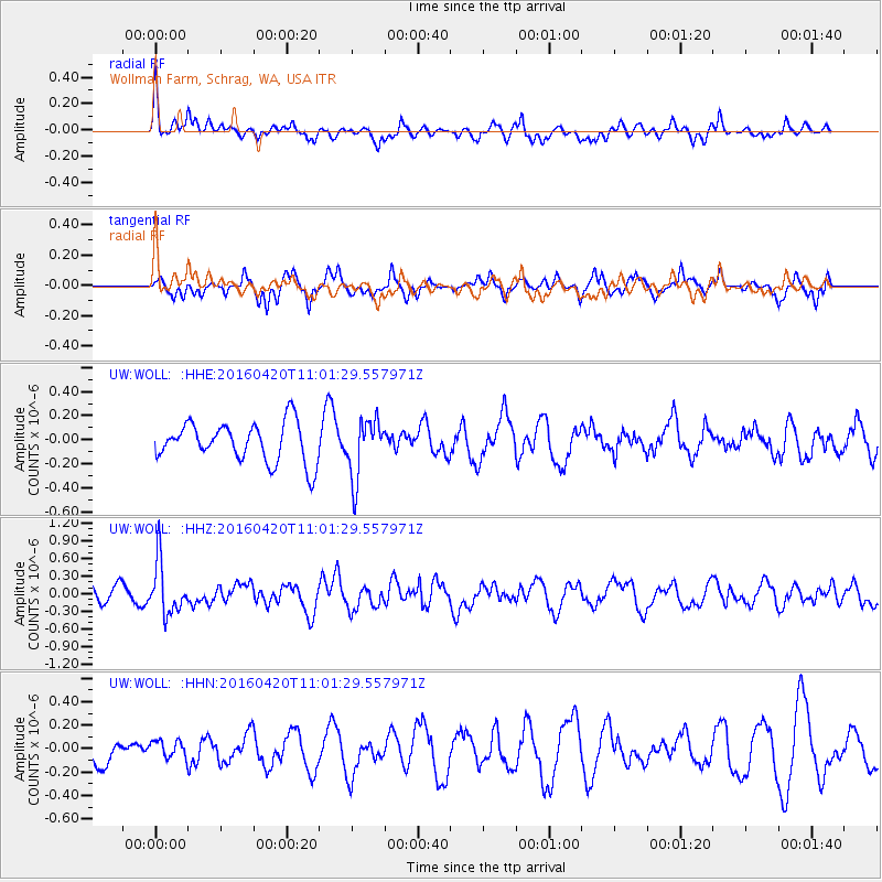
WOLL Wollman Farm, Schrag, WA, USA - Earthquake Result Viewer
*The percent match for this event was below the threshold and hence no stack was calculated.
| Earthquake location: |
North Atlantic Ocean |
| Earthquake latitude/longitude: |
13.2/-55.9 |
| Earthquake time(UTC): |
2016/04/20 (111) 10:51:39 GMT |
| Earthquake Depth: |
10 km |
| Earthquake Magnitude: |
5.8 MB |
| Earthquake Catalog/Contributor: |
NEIC PDE/NEIC COMCAT |
|
| Network: |
UW Pacific Northwest Regional Seismic Network |
| Station: |
WOLL Wollman Farm, Schrag, WA, USA |
| Lat/Lon: |
47.06 N/118.92 W |
| Elevation: |
385 m |
|
| Distance: |
62.1 deg |
| Az: |
316.425 deg |
| Baz: |
100.928 deg |
| Ray Param: |
$rayparam |
*The percent match for this event was below the threshold and hence was not used in the summary stack. |
|
| Radial Match: |
46.295746 % |
| Radial Bump: |
357 |
| Transverse Match: |
70.18489 % |
| Transverse Bump: |
352 |
| SOD ConfigId: |
7422571 |
| Insert Time: |
2019-04-22 10:12:13.702 +0000 |
| GWidth: |
2.5 |
| Max Bumps: |
400 |
| Tol: |
0.001 |
|
Signal To Noise
| Channel | StoN | STA | LTA |
| UW:WOLL: :HHZ:20160420T11:01:29.557971Z | 3.4942515 | 4.474271E-7 | 1.2804664E-7 |
| UW:WOLL: :HHN:20160420T11:01:29.557971Z | 0.55253613 | 7.483736E-8 | 1.3544337E-7 |
| UW:WOLL: :HHE:20160420T11:01:29.557971Z | 1.5101225 | 2.466499E-7 | 1.6333105E-7 |
| Arrivals |
| Ps | |
| PpPs | |
| PsPs/PpSs | |


