You are here: Home > Network List > US - United States National Seismic Network Stations List
> Station WMOK Wichita Mountains, Oklahoma, USA > Earthquake Result Viewer
WMOK Wichita Mountains, Oklahoma, USA - Earthquake Result Viewer

| Earthquake location: |
Fiji Islands Region |
| Earthquake latitude/longitude: |
-17.3/-176.9 |
| Earthquake time(UTC): |
2004/01/22 (022) 04:15:42 GMT |
| Earthquake Depth: |
30 km |
| Earthquake Magnitude: |
5.0 MB, 5.0 MS, 5.5 MW |
| Earthquake Catalog/Contributor: |
WHDF/NEIC |
|
| Network: |
US United States National Seismic Network |
| Station: |
WMOK Wichita Mountains, Oklahoma, USA |
| Lat/Lon: |
34.74 N/98.78 W |
| Elevation: |
486 m |
|
| Distance: |
90.3 deg |
| Az: |
53.7 deg |
| Baz: |
249.245 deg |
| Ray Param: |
0.041679718 |
| Estimated Moho Depth: |
21.75 km |
| Estimated Crust Vp/Vs: |
1.71 |
| Assumed Crust Vp: |
6.315 km/s |
| Estimated Crust Vs: |
3.699 km/s |
| Estimated Crust Poisson's Ratio: |
0.24 |
|
| Radial Match: |
98.111305 % |
| Radial Bump: |
67 |
| Transverse Match: |
98.245705 % |
| Transverse Bump: |
71 |
| SOD ConfigId: |
110165 |
| Insert Time: |
2010-03-05 02:00:47.990 +0000 |
| GWidth: |
2.5 |
| Max Bumps: |
400 |
| Tol: |
0.001 |
|
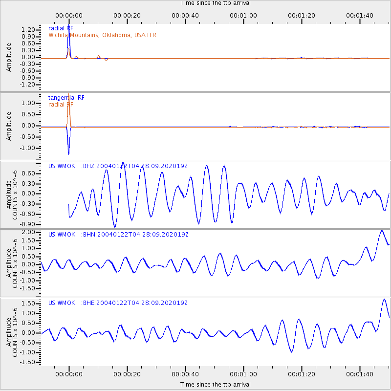
Signal To Noise
| Channel | StoN | STA | LTA |
| US:WMOK: :BHN:20040122T04:28:09.202019Z | 0.8921349 | 2.500568E-7 | 2.8029035E-7 |
| US:WMOK: :BHE:20040122T04:28:09.202019Z | 0.90598685 | 2.0742964E-7 | 2.2895436E-7 |
| US:WMOK: :BHZ:20040122T04:28:09.202019Z | 0.8802593 | 4.3394124E-7 | 4.9296983E-7 |
| Arrivals |
| Ps | 2.5 SECOND |
| PpPs | 9.1 SECOND |
| PsPs/PpSs | 12 SECOND |


