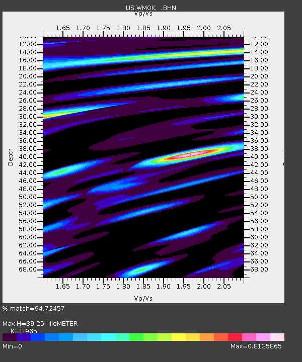
WMOK Wichita Mountains, Oklahoma, USA - Earthquake Result Viewer
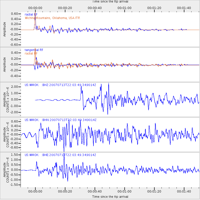
Earthquake location: Andreanof Islands, Aleutian Is.
Earthquake latitude/longitude: 51.8/-176.3
Earthquake time(UTC): 2007/07/13 (194) 21:54:43 GMT
Earthquake Depth: 35 km
Earthquake Magnitude: 5.7 MB, 5.6 MS, 6.0 MW, 5.9 MW
Earthquake Catalog/Contributor: WHDF/NEIC
Network: US United States National Seismic Network
Station: WMOK Wichita Mountains, Oklahoma, USA
Lat/Lon: 34.74 N/98.78 W
Elevation: 486 m
Distance: 56.3 deg
Az: 75.219 deg
Baz: 313.243 deg
Ray Param: 0.06419504
Estimated Moho Depth: 39.25 km
Estimated Crust Vp/Vs: 1.97
Assumed Crust Vp: 6.315 km/s
Estimated Crust Vs: 3.214 km/s
Estimated Crust Poisson's Ratio: 0.33
Radial Match: 94.72457 %
Radial Bump: 400
Transverse Match: 91.190384 %
Transverse Bump: 400
SOD ConfigId: 2564
Insert Time: 2010-03-05 02:01:56.961 +0000
GWidth: 2.5
Max Bumps: 400
Tol: 0.001

Signal To Noise

ChannelStoNSTALTA
US:WMOK: :BHN:20070713T22:03:49.349014Z7.5869673.1287058E-74.12379E-8
US:WMOK: :BHE:20070713T22:03:49.349014Z9.2000073.051864E-73.3172412E-8
US:WMOK: :BHZ:20070713T22:03:49.349014Z16.960049.845095E-75.8048773E-8
Arrivals
Ps6.3 SECOND
PpPs18 SECOND
PsPs/PpSs24 SECOND