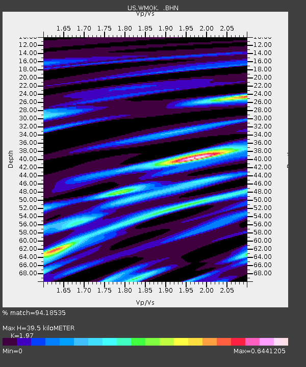
WMOK Wichita Mountains, Oklahoma, USA - Earthquake Result Viewer
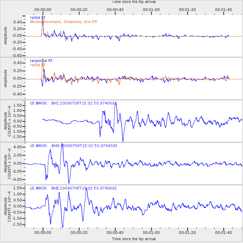
Earthquake location: Rat Islands, Aleutian Islands
Earthquake latitude/longitude: 50.4/177.0
Earthquake time(UTC): 2009/07/06 (187) 14:53:12 GMT
Earthquake Depth: 22 km
Earthquake Magnitude: 6.0 MB, 5.8 MS, 6.1 MW, 6.0 MW
Earthquake Catalog/Contributor: WHDF/NEIC
Network: US United States National Seismic Network
Station: WMOK Wichita Mountains, Oklahoma, USA
Lat/Lon: 34.74 N/98.78 W
Elevation: 486 m
Distance: 60.7 deg
Az: 69.949 deg
Baz: 313.161 deg
Ray Param: 0.061317526
Estimated Moho Depth: 39.5 km
Estimated Crust Vp/Vs: 1.97
Assumed Crust Vp: 6.315 km/s
Estimated Crust Vs: 3.206 km/s
Estimated Crust Poisson's Ratio: 0.33
Radial Match: 94.18535 %
Radial Bump: 302
Transverse Match: 75.13021 %
Transverse Bump: 400
SOD ConfigId: 2648
Insert Time: 2010-03-05 02:03:12.108 +0000
GWidth: 2.5
Max Bumps: 400
Tol: 0.001

Signal To Noise

ChannelStoNSTALTA
US:WMOK: :BHN:20090706T15:02:50.974009Z10.7017592.1037465E-61.965795E-7
US:WMOK: :BHE:20090706T15:02:50.974009Z3.30567676.149982E-71.8604305E-7
US:WMOK: :BHZ:20090706T15:02:50.974009Z5.14591366.243007E-71.213197E-7
Arrivals
Ps6.3 SECOND
PpPs18 SECOND
PsPs/PpSs24 SECOND