You are here: Home > Network List > US - United States National Seismic Network Stations List
> Station WMOK Wichita Mountains, Oklahoma, USA > Earthquake Result Viewer
WMOK Wichita Mountains, Oklahoma, USA - Earthquake Result Viewer
| Earthquake location: |
Eastern Siberia, Russia |
| Earthquake latitude/longitude: |
61.4/167.5 |
| Earthquake time(UTC): |
2006/04/21 (111) 11:14:15 GMT |
| Earthquake Depth: |
12 km |
| Earthquake Magnitude: |
5.8 MB, 5.8 MS, 6.1 MW, 6.1 MW |
| Earthquake Catalog/Contributor: |
WHDF/NEIC |
|
| Network: |
US United States National Seismic Network |
| Station: |
WMOK Wichita Mountains, Oklahoma, USA |
| Lat/Lon: |
34.74 N/98.78 W |
| Elevation: |
486 m |
|
| Distance: |
61.9 deg |
| Az: |
68.736 deg |
| Baz: |
326.956 deg |
| Ray Param: |
0.060594853 |
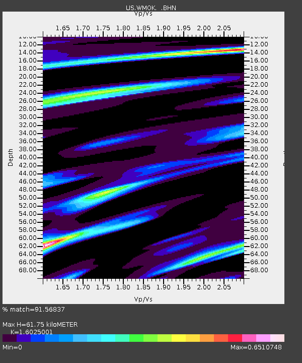
| Estimated Moho Depth: |
61.75 km |
| Estimated Crust Vp/Vs: |
1.60 |
| Assumed Crust Vp: |
6.315 km/s |
| Estimated Crust Vs: |
3.941 km/s |
| Estimated Crust Poisson's Ratio: |
0.18 |
|
| Radial Match: |
91.56837 % |
| Radial Bump: |
311 |
| Transverse Match: |
60.3818 % |
| Transverse Bump: |
400 |
| SOD ConfigId: |
2669 |
| Insert Time: |
2010-03-05 02:04:08.888 +0000 |
| GWidth: |
2.5 |
| Max Bumps: |
400 |
| Tol: |
0.001 |
|
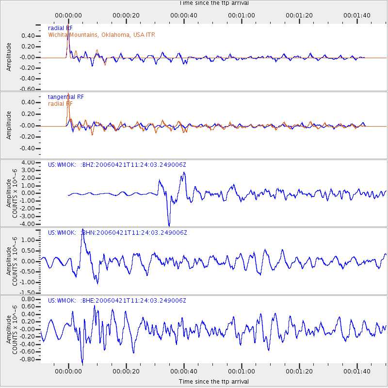
Signal To Noise
| Channel | StoN | STA | LTA |
| US:WMOK: :BHN:20060421T11:24:03.249006Z | 4.69615 | 5.0619667E-7 | 1.07789724E-7 |
| US:WMOK: :BHE:20060421T11:24:03.249006Z | 2.8150363 | 3.1514116E-7 | 1.1194924E-7 |
| US:WMOK: :BHZ:20060421T11:24:03.249006Z | 11.0460615 | 1.3308387E-6 | 1.2048083E-7 |
| Arrivals |
| Ps | 6.2 SECOND |
| PpPs | 24 SECOND |
| PsPs/PpSs | 30 SECOND |


