You are here: Home > Network List > US - United States National Seismic Network Stations List
> Station WMOK Wichita Mountains, Oklahoma, USA > Earthquake Result Viewer
WMOK Wichita Mountains, Oklahoma, USA - Earthquake Result Viewer
*The percent match for this event was below the threshold and hence no stack was calculated.
| Earthquake location: |
Western Brazil |
| Earthquake latitude/longitude: |
-8.1/-71.4 |
| Earthquake time(UTC): |
2009/01/29 (029) 22:28:05 GMT |
| Earthquake Depth: |
602 km |
| Earthquake Magnitude: |
5.7 MW, 5.3 MB, 5.6 MW |
| Earthquake Catalog/Contributor: |
WHDF/NEIC |
|
| Network: |
US United States National Seismic Network |
| Station: |
WMOK Wichita Mountains, Oklahoma, USA |
| Lat/Lon: |
34.74 N/98.78 W |
| Elevation: |
486 m |
|
| Distance: |
49.9 deg |
| Az: |
330.305 deg |
| Baz: |
143.445 deg |
| Ray Param: |
$rayparam |
*The percent match for this event was below the threshold and hence was not used in the summary stack. |
|
| Radial Match: |
61.87693 % |
| Radial Bump: |
400 |
| Transverse Match: |
71.066086 % |
| Transverse Bump: |
400 |
| SOD ConfigId: |
2658 |
| Insert Time: |
2010-03-05 02:04:26.836 +0000 |
| GWidth: |
2.5 |
| Max Bumps: |
400 |
| Tol: |
0.001 |
|
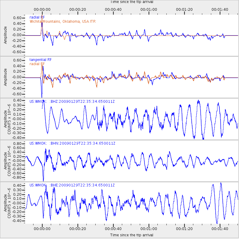
Signal To Noise
| Channel | StoN | STA | LTA |
| US:WMOK: :BHN:20090129T22:35:34.650011Z | 1.8813168 | 3.7145085E-7 | 1.9744195E-7 |
| US:WMOK: :BHE:20090129T22:35:34.650011Z | 1.2561179 | 2.1439536E-7 | 1.706809E-7 |
| US:WMOK: :BHZ:20090129T22:35:34.650011Z | 0.8559835 | 1.3523436E-7 | 1.5798712E-7 |
| Arrivals |
| Ps | |
| PpPs | |
| PsPs/PpSs | |


