You are here: Home > Network List > IU - Global Seismograph Network (GSN - IRIS/USGS) Stations List
> Station MACI Morro de la Arena, Canary Islands > Earthquake Result Viewer
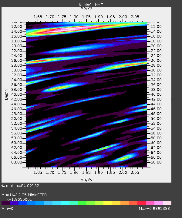
MACI Morro de la Arena, Canary Islands - Earthquake Result Viewer
| Earthquake location: |
Near Coast Of Ecuador |
| Earthquake latitude/longitude: |
-0.3/-80.5 |
| Earthquake time(UTC): |
2016/04/22 (113) 03:03:42 GMT |
| Earthquake Depth: |
10 km |
| Earthquake Magnitude: |
6.0 MO |
| Earthquake Catalog/Contributor: |
NEIC PDE/NEIC ALERT |
|
| Network: |
IU Global Seismograph Network (GSN - IRIS/USGS) |
| Station: |
MACI Morro de la Arena, Canary Islands |
| Lat/Lon: |
28.25 N/16.51 W |
| Elevation: |
1674 m |
|
| Distance: |
67.4 deg |
| Az: |
59.188 deg |
| Baz: |
256.782 deg |
| Ray Param: |
0.056951907 |
| Estimated Moho Depth: |
12.25 km |
| Estimated Crust Vp/Vs: |
1.81 |
| Assumed Crust Vp: |
4.662 km/s |
| Estimated Crust Vs: |
2.583 km/s |
| Estimated Crust Poisson's Ratio: |
0.28 |
|
| Radial Match: |
84.02132 % |
| Radial Bump: |
400 |
| Transverse Match: |
74.37317 % |
| Transverse Bump: |
400 |
| SOD ConfigId: |
7422571 |
| Insert Time: |
2019-04-22 10:30:11.357 +0000 |
| GWidth: |
2.5 |
| Max Bumps: |
400 |
| Tol: |
0.001 |
|

Signal To Noise
| Channel | StoN | STA | LTA |
| IU:MACI: :HHZ:20160422T03:14:05.940002Z | 16.639261 | 2.5705597E-6 | 1.5448761E-7 |
| IU:MACI: :HHN:20160422T03:14:05.940002Z | 2.720077 | 8.168694E-7 | 3.0031111E-7 |
| IU:MACI: :HHE:20160422T03:14:05.940002Z | 5.943319 | 1.3580461E-6 | 2.2849963E-7 |
| Arrivals |
| Ps | 2.2 SECOND |
| PpPs | 7.2 SECOND |
| PsPs/PpSs | 9.4 SECOND |


