You are here: Home > Network List > US - United States National Seismic Network Stations List
> Station WRAK Wrangell Island, Southeastern Alaska, Alaska, USA > Earthquake Result Viewer
WRAK Wrangell Island, Southeastern Alaska, Alaska, USA - Earthquake Result Viewer

| Earthquake location: |
Solomon Islands |
| Earthquake latitude/longitude: |
-9.4/158.0 |
| Earthquake time(UTC): |
2015/08/10 (222) 04:12:14 GMT |
| Earthquake Depth: |
10 km |
| Earthquake Magnitude: |
6.9 MO |
| Earthquake Catalog/Contributor: |
NEIC PDE/NEIC ALERT |
|
| Network: |
US United States National Seismic Network |
| Station: |
WRAK Wrangell Island, Southeastern Alaska, Alaska, USA |
| Lat/Lon: |
56.42 N/132.35 W |
| Elevation: |
81 m |
|
| Distance: |
86.8 deg |
| Az: |
31.457 deg |
| Baz: |
247.928 deg |
| Ray Param: |
0.04379549 |
| Estimated Moho Depth: |
68.0 km |
| Estimated Crust Vp/Vs: |
1.71 |
| Assumed Crust Vp: |
6.597 km/s |
| Estimated Crust Vs: |
3.864 km/s |
| Estimated Crust Poisson's Ratio: |
0.24 |
|
| Radial Match: |
88.54965 % |
| Radial Bump: |
400 |
| Transverse Match: |
82.63404 % |
| Transverse Bump: |
400 |
| SOD ConfigId: |
1085051 |
| Insert Time: |
2015-08-24 04:33:08.959 +0000 |
| GWidth: |
2.5 |
| Max Bumps: |
400 |
| Tol: |
0.001 |
|
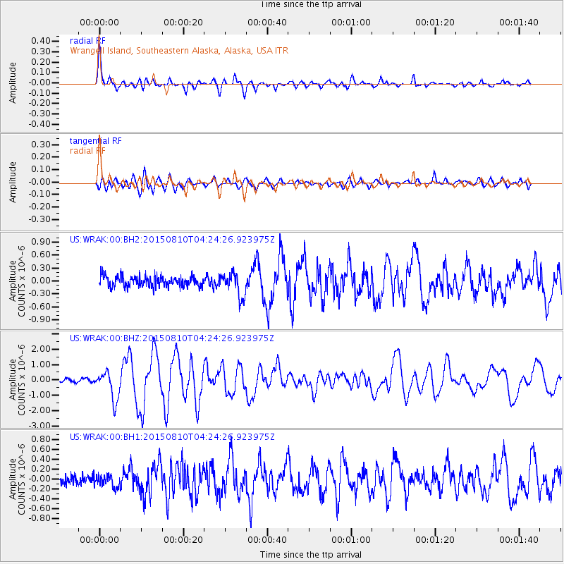
Signal To Noise
| Channel | StoN | STA | LTA |
| US:WRAK:00:BHZ:20150810T04:24:26.923975Z | 11.669503 | 9.508069E-7 | 8.147792E-8 |
| US:WRAK:00:BH1:20150810T04:24:26.923975Z | 1.0773076 | 1.1476037E-7 | 1.06525164E-7 |
| US:WRAK:00:BH2:20150810T04:24:26.923975Z | 2.3870904 | 2.825017E-7 | 1.1834562E-7 |
| Arrivals |
| Ps | 7.5 SECOND |
| PpPs | 27 SECOND |
| PsPs/PpSs | 35 SECOND |


