You are here: Home > Network List > US - United States National Seismic Network Stations List
> Station WMOK Wichita Mountains, Oklahoma, USA > Earthquake Result Viewer
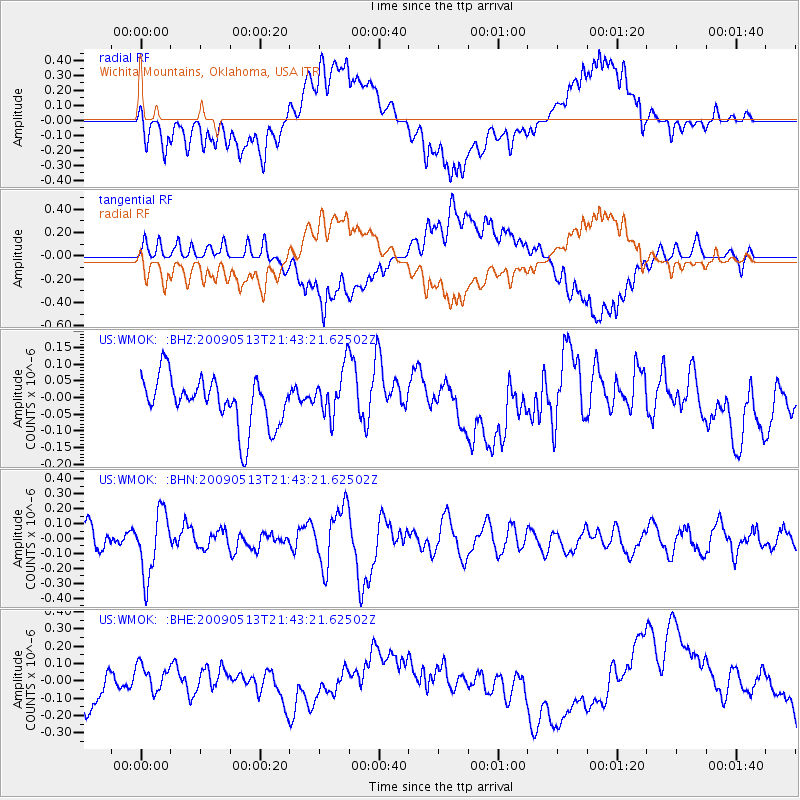
WMOK Wichita Mountains, Oklahoma, USA - Earthquake Result Viewer
*The percent match for this event was below the threshold and hence no stack was calculated.
| Earthquake location: |
Tonga Islands |
| Earthquake latitude/longitude: |
-15.8/-173.5 |
| Earthquake time(UTC): |
2009/05/13 (133) 21:31:17 GMT |
| Earthquake Depth: |
85 km |
| Earthquake Magnitude: |
5.8 MW, 5.3 MB, 5.8 MW |
| Earthquake Catalog/Contributor: |
WHDF/NEIC |
|
| Network: |
US United States National Seismic Network |
| Station: |
WMOK Wichita Mountains, Oklahoma, USA |
| Lat/Lon: |
34.74 N/98.78 W |
| Elevation: |
486 m |
|
| Distance: |
86.8 deg |
| Az: |
52.717 deg |
| Baz: |
248.483 deg |
| Ray Param: |
$rayparam |
*The percent match for this event was below the threshold and hence was not used in the summary stack. |
|
| Radial Match: |
60.662018 % |
| Radial Bump: |
400 |
| Transverse Match: |
56.097973 % |
| Transverse Bump: |
400 |
| SOD ConfigId: |
2760 |
| Insert Time: |
2010-03-05 02:05:00.219 +0000 |
| GWidth: |
2.5 |
| Max Bumps: |
400 |
| Tol: |
0.001 |
|
Signal To Noise
| Channel | StoN | STA | LTA |
| US:WMOK: :BHN:20090513T21:43:21.62502Z | 3.1671548 | 2.1158097E-7 | 6.6804745E-8 |
| US:WMOK: :BHE:20090513T21:43:21.62502Z | 0.6850072 | 8.1957936E-8 | 1.1964536E-7 |
| US:WMOK: :BHZ:20090513T21:43:21.62502Z | 0.9941437 | 7.2129026E-8 | 7.2553924E-8 |
| Arrivals |
| Ps | |
| PpPs | |
| PsPs/PpSs | |


