You are here: Home > Network List > US - United States National Seismic Network Stations List
> Station WMOK Wichita Mountains, Oklahoma, USA > Earthquake Result Viewer
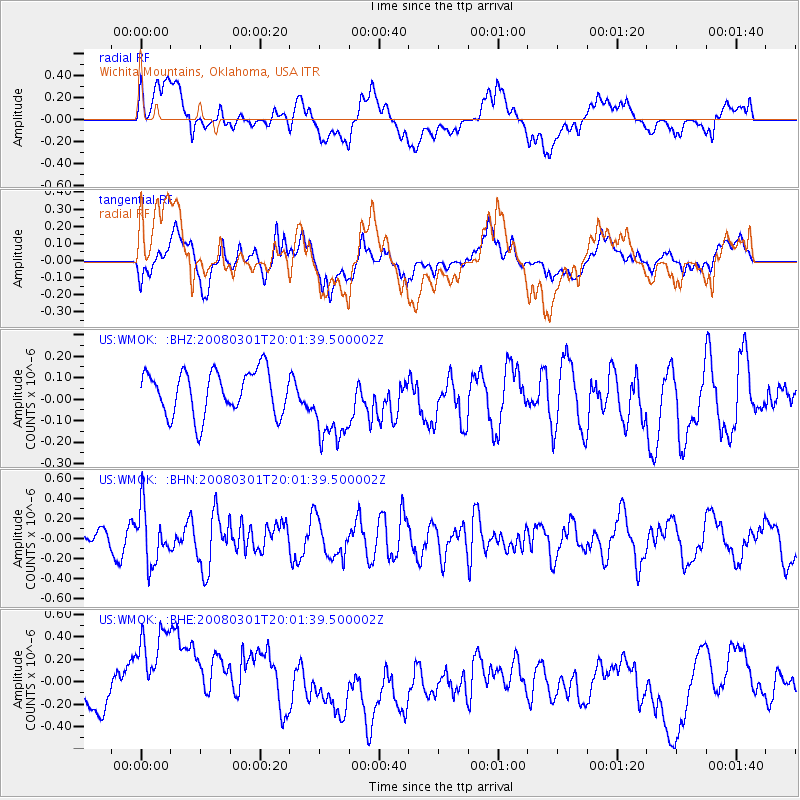
WMOK Wichita Mountains, Oklahoma, USA - Earthquake Result Viewer
*The percent match for this event was below the threshold and hence no stack was calculated.
| Earthquake location: |
Northern Chile |
| Earthquake latitude/longitude: |
-20.3/-69.9 |
| Earthquake time(UTC): |
2008/03/01 (061) 19:51:59 GMT |
| Earthquake Depth: |
37 km |
| Earthquake Magnitude: |
5.7 MB, 5.1 MS, 5.7 MW, 5.6 MW |
| Earthquake Catalog/Contributor: |
WHDF/NEIC |
|
| Network: |
US United States National Seismic Network |
| Station: |
WMOK Wichita Mountains, Oklahoma, USA |
| Lat/Lon: |
34.74 N/98.78 W |
| Elevation: |
486 m |
|
| Distance: |
61.2 deg |
| Az: |
333.036 deg |
| Baz: |
148.873 deg |
| Ray Param: |
$rayparam |
*The percent match for this event was below the threshold and hence was not used in the summary stack. |
|
| Radial Match: |
35.6395 % |
| Radial Bump: |
400 |
| Transverse Match: |
48.919548 % |
| Transverse Bump: |
400 |
| SOD ConfigId: |
2504 |
| Insert Time: |
2010-03-05 02:05:07.966 +0000 |
| GWidth: |
2.5 |
| Max Bumps: |
400 |
| Tol: |
0.001 |
|
Signal To Noise
| Channel | StoN | STA | LTA |
| US:WMOK: :BHN:20080301T20:01:39.500002Z | 2.5297434 | 2.7261945E-7 | 1.0776564E-7 |
| US:WMOK: :BHE:20080301T20:01:39.500002Z | 3.067849 | 6.135228E-7 | 1.9998468E-7 |
| US:WMOK: :BHZ:20080301T20:01:39.500002Z | 1.8288044 | 1.8614193E-7 | 1.017834E-7 |
| Arrivals |
| Ps | |
| PpPs | |
| PsPs/PpSs | |


