You are here: Home > Network List > N4 - Central and EAstern US Network Stations List
> Station T57A Hurt, VA, USA > Earthquake Result Viewer
T57A Hurt, VA, USA - Earthquake Result Viewer
| Earthquake location: |
Near Coast Of Ecuador |
| Earthquake latitude/longitude: |
-0.3/-80.5 |
| Earthquake time(UTC): |
2016/04/22 (113) 03:03:42 GMT |
| Earthquake Depth: |
10 km |
| Earthquake Magnitude: |
6.0 MO |
| Earthquake Catalog/Contributor: |
NEIC PDE/NEIC ALERT |
|
| Network: |
N4 Central and EAstern US Network |
| Station: |
T57A Hurt, VA, USA |
| Lat/Lon: |
37.00 N/79.25 W |
| Elevation: |
230 m |
|
| Distance: |
37.2 deg |
| Az: |
1.708 deg |
| Baz: |
182.134 deg |
| Ray Param: |
0.07628796 |
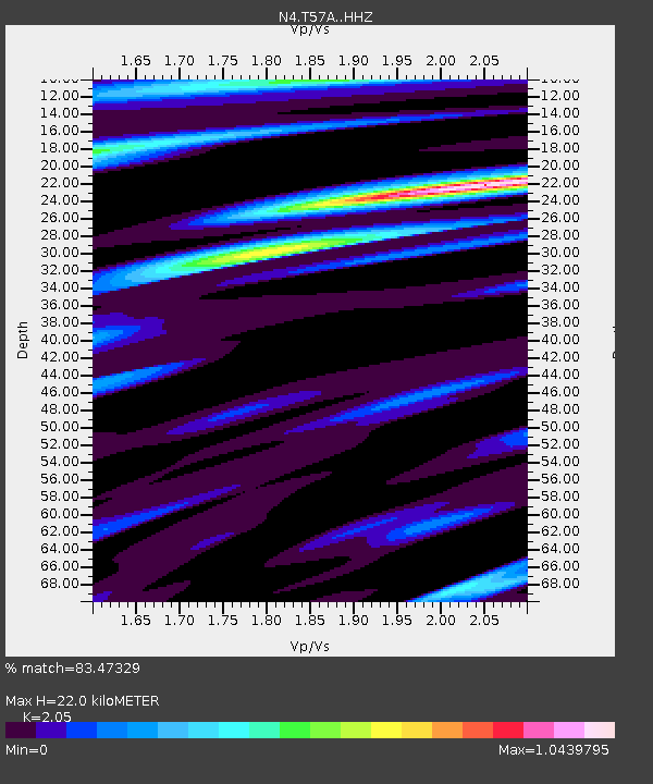
| Estimated Moho Depth: |
22.0 km |
| Estimated Crust Vp/Vs: |
2.05 |
| Assumed Crust Vp: |
6.419 km/s |
| Estimated Crust Vs: |
3.131 km/s |
| Estimated Crust Poisson's Ratio: |
0.34 |
|
| Radial Match: |
83.47329 % |
| Radial Bump: |
292 |
| Transverse Match: |
62.679745 % |
| Transverse Bump: |
400 |
| SOD ConfigId: |
7422571 |
| Insert Time: |
2019-04-22 10:32:23.748 +0000 |
| GWidth: |
2.5 |
| Max Bumps: |
400 |
| Tol: |
0.001 |
|

Signal To Noise
| Channel | StoN | STA | LTA |
| N4:T57A: :HHZ:20160422T03:10:21.540009Z | 6.6082764 | 7.7794704E-7 | 1.1772315E-7 |
| N4:T57A: :HHN:20160422T03:10:21.540009Z | 3.8803506 | 4.2450898E-7 | 1.0939965E-7 |
| N4:T57A: :HHE:20160422T03:10:21.540009Z | 0.6482475 | 6.955255E-8 | 1.07293204E-7 |
| Arrivals |
| Ps | 3.8 SECOND |
| PpPs | 9.8 SECOND |
| PsPs/PpSs | 14 SECOND |


