You are here: Home > Network List > N4 - Central and EAstern US Network Stations List
> Station Z38B Mount Pleasant, TX, USA > Earthquake Result Viewer
Z38B Mount Pleasant, TX, USA - Earthquake Result Viewer
| Earthquake location: |
Near Coast Of Ecuador |
| Earthquake latitude/longitude: |
-0.3/-80.5 |
| Earthquake time(UTC): |
2016/04/22 (113) 03:03:42 GMT |
| Earthquake Depth: |
10 km |
| Earthquake Magnitude: |
6.0 MO |
| Earthquake Catalog/Contributor: |
NEIC PDE/NEIC ALERT |
|
| Network: |
N4 Central and EAstern US Network |
| Station: |
Z38B Mount Pleasant, TX, USA |
| Lat/Lon: |
33.26 N/94.99 W |
| Elevation: |
115 m |
|
| Distance: |
36.1 deg |
| Az: |
339.212 deg |
| Baz: |
154.939 deg |
| Ray Param: |
0.07687995 |
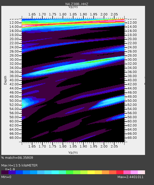
| Estimated Moho Depth: |
13.5 km |
| Estimated Crust Vp/Vs: |
1.60 |
| Assumed Crust Vp: |
6.245 km/s |
| Estimated Crust Vs: |
3.903 km/s |
| Estimated Crust Poisson's Ratio: |
0.18 |
|
| Radial Match: |
86.35909 % |
| Radial Bump: |
400 |
| Transverse Match: |
52.221775 % |
| Transverse Bump: |
350 |
| SOD ConfigId: |
7422571 |
| Insert Time: |
2019-04-22 10:32:46.711 +0000 |
| GWidth: |
2.5 |
| Max Bumps: |
400 |
| Tol: |
0.001 |
|

Signal To Noise
| Channel | StoN | STA | LTA |
| N4:Z38B: :HHZ:20160422T03:10:12.429993Z | 3.5837843 | 6.5071987E-7 | 1.8157338E-7 |
| N4:Z38B: :HHN:20160422T03:10:12.429993Z | 1.5638511 | 4.7293497E-7 | 3.0241688E-7 |
| N4:Z38B: :HHE:20160422T03:10:12.429993Z | 1.0836803 | 2.9867508E-7 | 2.7561182E-7 |
| Arrivals |
| Ps | 1.4 SECOND |
| PpPs | 5.2 SECOND |
| PsPs/PpSs | 6.6 SECOND |


