You are here: Home > Network List > US - United States National Seismic Network Stations List
> Station WMOK Wichita Mountains, Oklahoma, USA > Earthquake Result Viewer
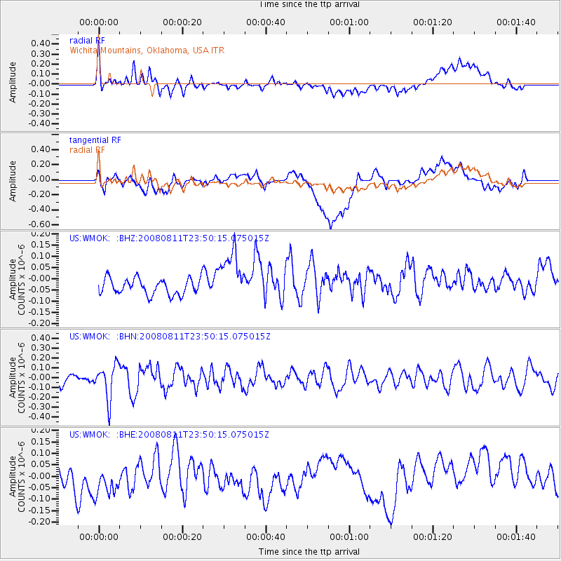
WMOK Wichita Mountains, Oklahoma, USA - Earthquake Result Viewer
*The percent match for this event was below the threshold and hence no stack was calculated.
| Earthquake location: |
Central Mid-Atlantic Ridge |
| Earthquake latitude/longitude: |
-1.0/-21.8 |
| Earthquake time(UTC): |
2008/08/11 (224) 23:38:38 GMT |
| Earthquake Depth: |
13 km |
| Earthquake Magnitude: |
6.0 MW, 5.2 MS, 5.4 MB, 6.0 MW |
| Earthquake Catalog/Contributor: |
WHDF/NEIC |
|
| Network: |
US United States National Seismic Network |
| Station: |
WMOK Wichita Mountains, Oklahoma, USA |
| Lat/Lon: |
34.74 N/98.78 W |
| Elevation: |
486 m |
|
| Distance: |
79.9 deg |
| Az: |
305.415 deg |
| Baz: |
98.338 deg |
| Ray Param: |
$rayparam |
*The percent match for this event was below the threshold and hence was not used in the summary stack. |
|
| Radial Match: |
58.137257 % |
| Radial Bump: |
400 |
| Transverse Match: |
50.534035 % |
| Transverse Bump: |
400 |
| SOD ConfigId: |
2504 |
| Insert Time: |
2010-03-05 02:05:31.924 +0000 |
| GWidth: |
2.5 |
| Max Bumps: |
400 |
| Tol: |
0.001 |
|
Signal To Noise
| Channel | StoN | STA | LTA |
| US:WMOK: :BHN:20080811T23:50:15.075015Z | 2.7529857 | 1.7932012E-7 | 6.51366E-8 |
| US:WMOK: :BHE:20080811T23:50:15.075015Z | 1.5386463 | 9.2250765E-8 | 5.9955795E-8 |
| US:WMOK: :BHZ:20080811T23:50:15.075015Z | 3.2245066 | 1.1574111E-7 | 3.5894207E-8 |
| Arrivals |
| Ps | |
| PpPs | |
| PsPs/PpSs | |


