You are here: Home > Network List > US - United States National Seismic Network Stations List
> Station WMOK Wichita Mountains, Oklahoma, USA > Earthquake Result Viewer
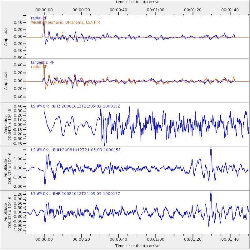
WMOK Wichita Mountains, Oklahoma, USA - Earthquake Result Viewer
*The percent match for this event was below the threshold and hence no stack was calculated.
| Earthquake location: |
Southern Bolivia |
| Earthquake latitude/longitude: |
-20.1/-65.0 |
| Earthquake time(UTC): |
2008/10/12 (286) 20:55:41 GMT |
| Earthquake Depth: |
353 km |
| Earthquake Magnitude: |
6.0 MB, 6.2 MW, 6.2 MW |
| Earthquake Catalog/Contributor: |
WHDF/NEIC |
|
| Network: |
US United States National Seismic Network |
| Station: |
WMOK Wichita Mountains, Oklahoma, USA |
| Lat/Lon: |
34.74 N/98.78 W |
| Elevation: |
486 m |
|
| Distance: |
63.3 deg |
| Az: |
329.145 deg |
| Baz: |
144.183 deg |
| Ray Param: |
$rayparam |
*The percent match for this event was below the threshold and hence was not used in the summary stack. |
|
| Radial Match: |
76.2893 % |
| Radial Bump: |
400 |
| Transverse Match: |
55.472652 % |
| Transverse Bump: |
400 |
| SOD ConfigId: |
2556 |
| Insert Time: |
2010-03-05 02:05:35.862 +0000 |
| GWidth: |
2.5 |
| Max Bumps: |
400 |
| Tol: |
0.001 |
|
Signal To Noise
| Channel | StoN | STA | LTA |
| US:WMOK: :BHN:20081012T21:05:03.100015Z | 7.3319254 | 8.264169E-7 | 1.1271485E-7 |
| US:WMOK: :BHE:20081012T21:05:03.100015Z | 3.6545053 | 3.3080647E-7 | 9.0520174E-8 |
| US:WMOK: :BHZ:20081012T21:05:03.100015Z | 1.9325532 | 2.1654336E-7 | 1.120504E-7 |
| Arrivals |
| Ps | |
| PpPs | |
| PsPs/PpSs | |


