You are here: Home > Network List > TA - USArray Transportable Network (new EarthScope stations) Stations List
> Station I23K Minto, Yukon-Koyukuk, AK, USA > Earthquake Result Viewer
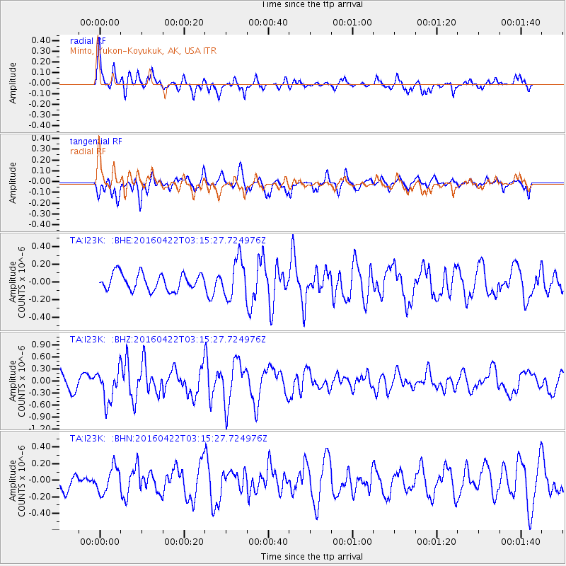
I23K Minto, Yukon-Koyukuk, AK, USA - Earthquake Result Viewer
*The percent match for this event was below the threshold and hence no stack was calculated.
| Earthquake location: |
Near Coast Of Ecuador |
| Earthquake latitude/longitude: |
-0.3/-80.5 |
| Earthquake time(UTC): |
2016/04/22 (113) 03:03:42 GMT |
| Earthquake Depth: |
10 km |
| Earthquake Magnitude: |
6.0 MO |
| Earthquake Catalog/Contributor: |
NEIC PDE/NEIC ALERT |
|
| Network: |
TA USArray Transportable Network (new EarthScope stations) |
| Station: |
I23K Minto, Yukon-Koyukuk, AK, USA |
| Lat/Lon: |
65.15 N/149.36 W |
| Elevation: |
149 m |
|
| Distance: |
81.5 deg |
| Az: |
336.521 deg |
| Baz: |
109.484 deg |
| Ray Param: |
$rayparam |
*The percent match for this event was below the threshold and hence was not used in the summary stack. |
|
| Radial Match: |
75.55662 % |
| Radial Bump: |
400 |
| Transverse Match: |
64.96021 % |
| Transverse Bump: |
400 |
| SOD ConfigId: |
7422571 |
| Insert Time: |
2019-04-22 10:34:43.460 +0000 |
| GWidth: |
2.5 |
| Max Bumps: |
400 |
| Tol: |
0.001 |
|
Signal To Noise
| Channel | StoN | STA | LTA |
| TA:I23K: :BHZ:20160422T03:15:27.724976Z | 2.0379617 | 4.0217904E-7 | 1.9734375E-7 |
| TA:I23K: :BHN:20160422T03:15:27.724976Z | 1.2970335 | 1.5571403E-7 | 1.2005397E-7 |
| TA:I23K: :BHE:20160422T03:15:27.724976Z | 2.5060606 | 2.3463511E-7 | 9.3627065E-8 |
| Arrivals |
| Ps | |
| PpPs | |
| PsPs/PpSs | |


