You are here: Home > Network List > TA - USArray Transportable Network (new EarthScope stations) Stations List
> Station M31M Drury Creek, Yukon, CA > Earthquake Result Viewer
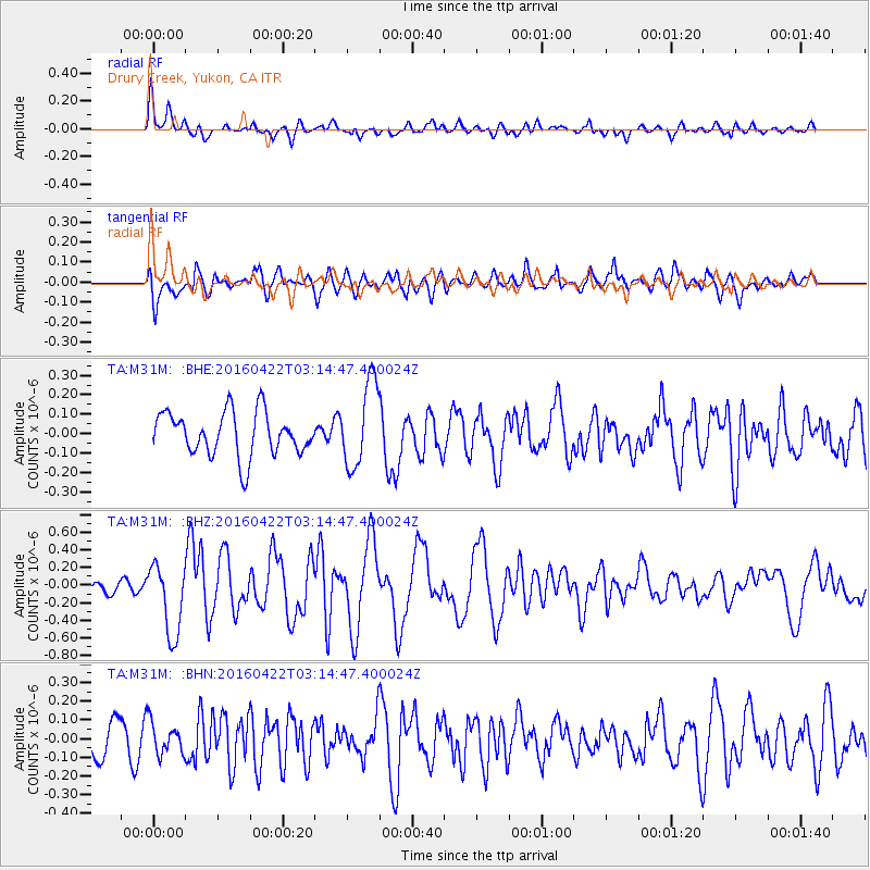
M31M Drury Creek, Yukon, CA - Earthquake Result Viewer
*The percent match for this event was below the threshold and hence no stack was calculated.
| Earthquake location: |
Near Coast Of Ecuador |
| Earthquake latitude/longitude: |
-0.3/-80.5 |
| Earthquake time(UTC): |
2016/04/22 (113) 03:03:42 GMT |
| Earthquake Depth: |
10 km |
| Earthquake Magnitude: |
6.0 MO |
| Earthquake Catalog/Contributor: |
NEIC PDE/NEIC ALERT |
|
| Network: |
TA USArray Transportable Network (new EarthScope stations) |
| Station: |
M31M Drury Creek, Yukon, CA |
| Lat/Lon: |
62.20 N/134.39 W |
| Elevation: |
639 m |
|
| Distance: |
74.2 deg |
| Az: |
336.839 deg |
| Baz: |
122.969 deg |
| Ray Param: |
$rayparam |
*The percent match for this event was below the threshold and hence was not used in the summary stack. |
|
| Radial Match: |
52.632317 % |
| Radial Bump: |
400 |
| Transverse Match: |
55.11367 % |
| Transverse Bump: |
400 |
| SOD ConfigId: |
7422571 |
| Insert Time: |
2019-04-22 10:35:03.535 +0000 |
| GWidth: |
2.5 |
| Max Bumps: |
400 |
| Tol: |
0.001 |
|
Signal To Noise
| Channel | StoN | STA | LTA |
| TA:M31M: :BHZ:20160422T03:14:47.400024Z | 3.4511955 | 4.0661212E-7 | 1.1781776E-7 |
| TA:M31M: :BHN:20160422T03:14:47.400024Z | 0.6999663 | 8.384836E-8 | 1.1978914E-7 |
| TA:M31M: :BHE:20160422T03:14:47.400024Z | 1.9787126 | 2.2215052E-7 | 1.1227023E-7 |
| Arrivals |
| Ps | |
| PpPs | |
| PsPs/PpSs | |


