You are here: Home > Network List > US - United States National Seismic Network Stations List
> Station WMOK Wichita Mountains, Oklahoma, USA > Earthquake Result Viewer
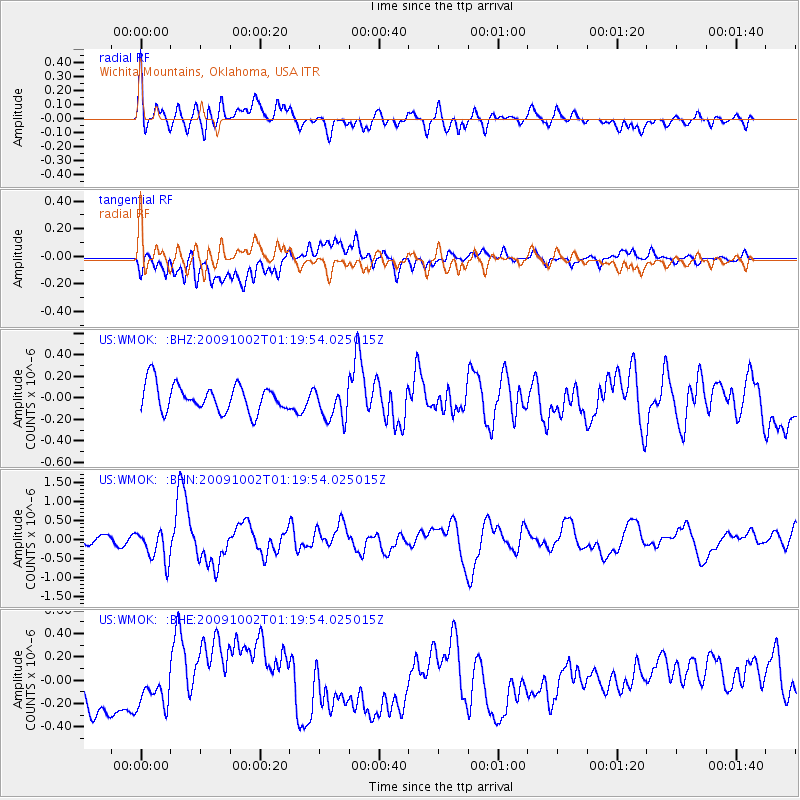
WMOK Wichita Mountains, Oklahoma, USA - Earthquake Result Viewer
*The percent match for this event was below the threshold and hence no stack was calculated.
| Earthquake location: |
Tonga Islands |
| Earthquake latitude/longitude: |
-16.3/-173.5 |
| Earthquake time(UTC): |
2009/10/02 (275) 01:07:39 GMT |
| Earthquake Depth: |
8.0 km |
| Earthquake Magnitude: |
6.1 MB, 6.0 MS, 6.1 MW, 6.1 MW |
| Earthquake Catalog/Contributor: |
WHDF/NEIC |
|
| Network: |
US United States National Seismic Network |
| Station: |
WMOK Wichita Mountains, Oklahoma, USA |
| Lat/Lon: |
34.74 N/98.78 W |
| Elevation: |
486 m |
|
| Distance: |
87.1 deg |
| Az: |
52.687 deg |
| Baz: |
248.008 deg |
| Ray Param: |
$rayparam |
*The percent match for this event was below the threshold and hence was not used in the summary stack. |
|
| Radial Match: |
54.949085 % |
| Radial Bump: |
400 |
| Transverse Match: |
37.71828 % |
| Transverse Bump: |
400 |
| SOD ConfigId: |
2622 |
| Insert Time: |
2010-03-05 02:05:47.691 +0000 |
| GWidth: |
2.5 |
| Max Bumps: |
400 |
| Tol: |
0.001 |
|
Signal To Noise
| Channel | StoN | STA | LTA |
| US:WMOK: :BHN:20091002T01:19:54.025015Z | 4.010321 | 4.1750013E-7 | 1.0410641E-7 |
| US:WMOK: :BHE:20091002T01:19:54.025015Z | 0.79734075 | 1.4779793E-7 | 1.8536358E-7 |
| US:WMOK: :BHZ:20091002T01:19:54.025015Z | 1.2370712 | 1.5614262E-7 | 1.2621959E-7 |
| Arrivals |
| Ps | |
| PpPs | |
| PsPs/PpSs | |


