You are here: Home > Network List > US - United States National Seismic Network Stations List
> Station WMOK Wichita Mountains, Oklahoma, USA > Earthquake Result Viewer
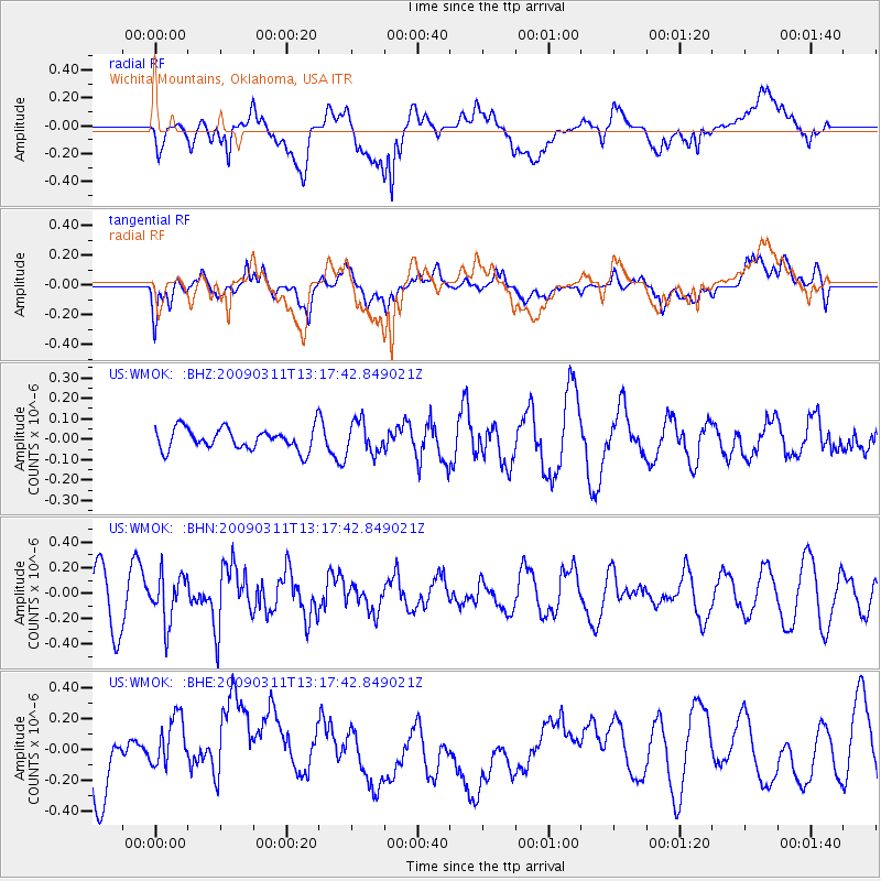
WMOK Wichita Mountains, Oklahoma, USA - Earthquake Result Viewer
*The percent match for this event was below the threshold and hence no stack was calculated.
| Earthquake location: |
San Juan Province, Argentina |
| Earthquake latitude/longitude: |
-31.9/-69.2 |
| Earthquake time(UTC): |
2009/03/11 (070) 13:06:53 GMT |
| Earthquake Depth: |
28 km |
| Earthquake Magnitude: |
5.5 MB, 4.8 MS, 5.3 MW, 5.5 ML |
| Earthquake Catalog/Contributor: |
WHDF/NEIC |
|
| Network: |
US United States National Seismic Network |
| Station: |
WMOK Wichita Mountains, Oklahoma, USA |
| Lat/Lon: |
34.74 N/98.78 W |
| Elevation: |
486 m |
|
| Distance: |
71.9 deg |
| Az: |
334.665 deg |
| Baz: |
153.767 deg |
| Ray Param: |
$rayparam |
*The percent match for this event was below the threshold and hence was not used in the summary stack. |
|
| Radial Match: |
48.618454 % |
| Radial Bump: |
400 |
| Transverse Match: |
41.568996 % |
| Transverse Bump: |
400 |
| SOD ConfigId: |
2658 |
| Insert Time: |
2010-03-05 02:06:15.260 +0000 |
| GWidth: |
2.5 |
| Max Bumps: |
400 |
| Tol: |
0.001 |
|
Signal To Noise
| Channel | StoN | STA | LTA |
| US:WMOK: :BHN:20090311T13:17:42.849021Z | 1.0895967 | 1.8676003E-7 | 1.7140289E-7 |
| US:WMOK: :BHE:20090311T13:17:42.849021Z | 1.0964957 | 2.3341069E-7 | 2.1286965E-7 |
| US:WMOK: :BHZ:20090311T13:17:42.849021Z | 1.4716314 | 7.8339475E-8 | 5.3233084E-8 |
| Arrivals |
| Ps | |
| PpPs | |
| PsPs/PpSs | |


