You are here: Home > Network List > US - United States National Seismic Network Stations List
> Station WMOK Wichita Mountains, Oklahoma, USA > Earthquake Result Viewer
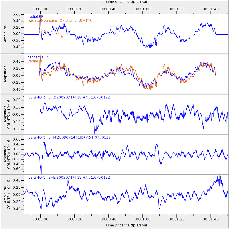
WMOK Wichita Mountains, Oklahoma, USA - Earthquake Result Viewer
*The percent match for this event was below the threshold and hence no stack was calculated.
| Earthquake location: |
Chile-Bolivia Border Region |
| Earthquake latitude/longitude: |
-21.8/-67.1 |
| Earthquake time(UTC): |
2009/07/14 (195) 18:38:08 GMT |
| Earthquake Depth: |
176 km |
| Earthquake Magnitude: |
5.7 MW, 5.4 MB, 5.7 MW |
| Earthquake Catalog/Contributor: |
WHDF/NEIC |
|
| Network: |
US United States National Seismic Network |
| Station: |
WMOK Wichita Mountains, Oklahoma, USA |
| Lat/Lon: |
34.74 N/98.78 W |
| Elevation: |
486 m |
|
| Distance: |
63.8 deg |
| Az: |
331.17 deg |
| Baz: |
147.038 deg |
| Ray Param: |
$rayparam |
*The percent match for this event was below the threshold and hence was not used in the summary stack. |
|
| Radial Match: |
66.112755 % |
| Radial Bump: |
400 |
| Transverse Match: |
63.875443 % |
| Transverse Bump: |
400 |
| SOD ConfigId: |
2648 |
| Insert Time: |
2010-03-05 02:06:29.773 +0000 |
| GWidth: |
2.5 |
| Max Bumps: |
400 |
| Tol: |
0.001 |
|
Signal To Noise
| Channel | StoN | STA | LTA |
| US:WMOK: :BHN:20090714T18:47:51.075012Z | 5.803718 | 3.5538798E-7 | 6.123454E-8 |
| US:WMOK: :BHE:20090714T18:47:51.075012Z | 2.9734733 | 2.9283518E-7 | 9.848253E-8 |
| US:WMOK: :BHZ:20090714T18:47:51.075012Z | 3.5299494 | 1.8948334E-7 | 5.367877E-8 |
| Arrivals |
| Ps | |
| PpPs | |
| PsPs/PpSs | |


