You are here: Home > Network List > UW - Pacific Northwest Regional Seismic Network Stations List
> Station UMAT Pilot Rock, OR, USA > Earthquake Result Viewer
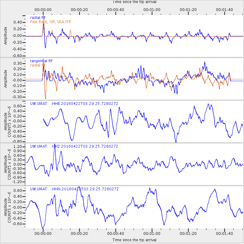
UMAT Pilot Rock, OR, USA - Earthquake Result Viewer
*The percent match for this event was below the threshold and hence no stack was calculated.
| Earthquake location: |
Near Coast Of Ecuador |
| Earthquake latitude/longitude: |
-0.3/-80.5 |
| Earthquake time(UTC): |
2016/04/22 (113) 03:20:13 GMT |
| Earthquake Depth: |
10 km |
| Earthquake Magnitude: |
5.8 MO |
| Earthquake Catalog/Contributor: |
NEIC PDE/NEIC ALERT |
|
| Network: |
UW Pacific Northwest Regional Seismic Network |
| Station: |
UMAT Pilot Rock, OR, USA |
| Lat/Lon: |
45.29 N/118.96 W |
| Elevation: |
1318 m |
|
| Distance: |
56.7 deg |
| Az: |
328.312 deg |
| Baz: |
131.915 deg |
| Ray Param: |
$rayparam |
*The percent match for this event was below the threshold and hence was not used in the summary stack. |
|
| Radial Match: |
50.343967 % |
| Radial Bump: |
282 |
| Transverse Match: |
24.97395 % |
| Transverse Bump: |
400 |
| SOD ConfigId: |
7422571 |
| Insert Time: |
2019-04-22 10:44:23.529 +0000 |
| GWidth: |
2.5 |
| Max Bumps: |
400 |
| Tol: |
0.001 |
|
Signal To Noise
| Channel | StoN | STA | LTA |
| UW:UMAT: :HHZ:20160422T03:29:25.728027Z | 2.1173482 | 4.5741578E-7 | 2.1603239E-7 |
| UW:UMAT: :HHN:20160422T03:29:25.728027Z | 1.1837353 | 4.3304235E-7 | 3.65827E-7 |
| UW:UMAT: :HHE:20160422T03:29:25.728027Z | 0.9931588 | 2.8230843E-7 | 2.8425305E-7 |
| Arrivals |
| Ps | |
| PpPs | |
| PsPs/PpSs | |


